


vtt rots thaon 22 kms

aubinjoel
Benutzer
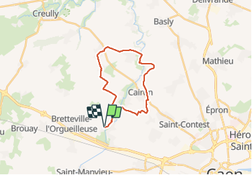

Länge
21 km

Maximale Höhe
63 m

Positive Höhendifferenz
166 m
Km-Effort
24 km

Min. Höhe
23 m

Negative Höhendifferenz
166 m
Boucle
Ja
Erstellungsdatum :
2019-01-15 12:42:28.146
Letzte Änderung :
2019-01-15 12:42:28.146
--
Schwierigkeit : Einfach

Kostenlosegpshiking-Anwendung
 SityTrail
IGN / Geografische Institute
SityTrail Plus
Die Welt öffnet sich für Sie
Über SityTrail
Tour Mountainbike von 21 km verfügbar auf Normandie, Calvados, Rots. Diese Tour wird von aubinjoel vorgeschlagen.
Ort
Land:
France
Region :
Normandie
Abteilung/Provinz :
Calvados
Kommune :
Rots
Standort:
Rots
Gehen Sie:(Dec)
Gehen Sie:(UTM)
683404 ; 5454061 (30U) N.
Kommentare