Tour Wandern Buysscheure - Découverte du Bocage Flamand - Buysscheure - Photo

Découverte du Bocage Flamand - Buysscheure

 tracegps
tracegps

Benutzer

© OpenStreetMap contributors
Länge
Länge
2,7 km
Maximale Höhe
Maximale Höhe
30 m
Positive Höhendifferenz
20 m
Km-Effort
Km-Effort  
3 km
Min. Höhe
Min. Höhe
14 m
Negative Höhendifferenz
21 m
Boucle
Boucle
Ja
Erstellungsdatum :
2014-12-10 00:00:00.0
Letzte Änderung :
2014-12-10 00:00:00.0

(1 Nachricht)

Wandern
Wandern
45m
Schwierigkeit : Einfach

Scannen Sie diesen QR-Code, um die Tour in der SityTrail-Anwendung zu öffnen

Kostenlosegpshiking-Anwendung

Logo SityTrail SityTrail

IGN / Geografische Institute

SityTrail aus dem App Store herunterladen SityTrail von Google Play herunterladen

Logo SityTrail SityTrail World

Die Welt öffnet sich für Sie

SityTrail aus dem App Store herunterladen SityTrail von Google Play herunterladen SityTrail auf Huawei AppGallery herunterladen

Über SityTrail

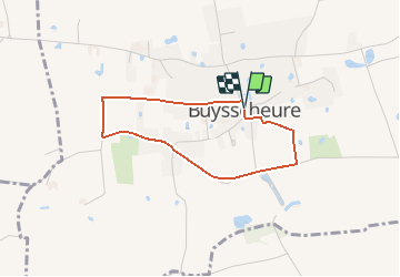
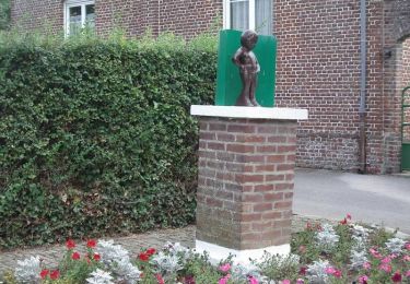
Tour Wandern von 2,7 km verfügbar auf Nordfrankreich, Nord, Buysscheure. Diese Tour wird von tracegps vorgeschlagen.

Beschreibung

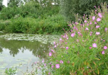
Circuit proposé par l’association Buysscheure bocage. Départ de l’église de Buysscheure. Circuit familial autour de Buysscheure; il emprunte une petite route et des chemins bocagers dont l'association Buysscheure Bocage et la commune ont contribué à la sauvegarde. Ce circuit a été numérisé par les randonneurs du CODEPEM.

Höhenprofil

Foto-Galerie

Ort

Land:
France
Region :
Nordfrankreich
Abteilung/Provinz :
Nord
Kommune :
Buysscheure
Standort:
Unknown
Gehen Sie:(Dec)
Gehen Sie:(UTM)
453033 ; 5628226 (31U) N.

Kommentare

Bitte melden Sie sich an, um einen Kommentar oder eine Bewertung zu hinterlassen


Touren in der Umgebung

Tour Wandern Clairmarais - Clairmarai - Photo
Wandern
yves62410

Wandern

Schwierig
(1)
Clairmarais, Nordfrankreich, Pas-de-Calais, France
19,6 km | 21 km-effort
5h 8min
Nein
Tour Wandern Nieurlet - Circuit de Booneghem -Nieurlet - Photo
Wandern
tracegps

Wandern

Medium
(1)
Nieurlet, Nordfrankreich, Nord, France
9,6 km | 10,1 km-effort
2h 30min
Ja
Tour Wandern Buysscheure - Vers le paradis - Photo
Wandern

Wandern

Sehr leicht
(1)
Buysscheure, Nordfrankreich, Nord, France
7,1 km | 7,8 km-effort
Unbekannt
Ja
Tour sport Clairmarais - À la découverte du marais audomarois - Photo
sport
tenace

sport

Sehr leicht
(1)
Clairmarais, Nordfrankreich, Pas-de-Calais, France
6,8 km | 7,2 km-effort
Unbekannt
Ja
Tour Zu Fuß Clairmarais - activity_1282864488 - Photo
Zu Fuß
GUIDE
Peter.vdbergh

Zu Fuß

Medium
Clairmarais, Nordfrankreich, Pas-de-Calais, France
14,9 km | 16,1 km-effort
3h 59min
Ja
Tour Wandern Nieurlet - Circuit de Booneghem - Photo
Wandern

Wandern

Sehr leicht
Nieurlet, Nordfrankreich, Nord, France
8,6 km | 9,1 km-effort
Unbekannt
Ja
Tour Wandern Clairmarais - copie - Photo
Wandern
Bernard.voyageur

Wandern

Einfach
Clairmarais, Nordfrankreich, Pas-de-Calais, France
8,1 km | 8,5 km-effort
2h 4min
Ja
Tour Fahrrad Volckerinckhove - Boucle de Volckerinckhove - Photo
Fahrrad
tracegps

Fahrrad

Einfach
Volckerinckhove, Nordfrankreich, Nord, France
29 km | 31 km-effort
1h 30min
Ja
Tour Wandern Buysscheure - Vers le Paradis - Buysscheure - Photo
Wandern
tracegps

Wandern

Medium
Buysscheure, Nordfrankreich, Nord, France
7,8 km | 8,6 km-effort
2h 0min
Ja


Schließen
Meine Abonnements