![](/images/other/stat-length.png)
![Tour Mountainbike Chaumergy - VTT Maison des étangs Ouest - Chaumergy - Photo](https://media.geolcdn.com/t/1900/400/ext.pjpeg?maxdim=2&url=https%3A%2F%2Fservices.sitytrail.com%2FGeolivesWS%2FDownloadMedia.ashx%3FTrailID%3D111439%26Media%3D7270_2.jpg)
VTT Maison des étangs Ouest - Chaumergy
tracegps
Benutzer
![Länge](/images/other/stat-length.png)
Länge
21 km
![Maximale Höhe](https://static1.geolcdn.com/siteimages/upload/files/1508320355ic_sort_altitude_max_24dp.png)
Maximale Höhe
231 m
![Positive Höhendifferenz](https://static1.geolcdn.com/siteimages/upload/files/1508320355ic_sort_den_pos_24dp.png)
Positive Höhendifferenz
184 m
![Km-Effort](/images/other/stat-length.png)
Km-Effort
23 km
![Min. Höhe](https://static1.geolcdn.com/siteimages/upload/files/1508320355ic_sort_altitude_min_24dp.png)
Min. Höhe
197 m
![Negative Höhendifferenz](https://static1.geolcdn.com/siteimages/upload/files/1508320355ic_sort_den_neg_24dp.png)
Negative Höhendifferenz
187 m
![Boucle](https://static1.geolcdn.com/siteimages/upload/files/16400158638029165_repeat_loop_refresh_sync_direction_icon.png)
Boucle
Ja
Erstellungsdatum :
2014-12-10 00:00:00.0
Letzte Änderung :
2014-12-10 00:00:00.0
![Mountainbike](https://static1.geolcdn.com/sitytour/trail-icons/202.png)
2h00
Schwierigkeit : Einfach
![Scannen Sie diesen QR-Code, um die Tour in der SityTrail-Anwendung zu öffnen](https://capi.geolives.com/qq0zvz2zws4bq2lad0pu/sitytour/trails/111439/qr.png?size=200)
Kostenlosegpshiking-Anwendung
Über SityTrail
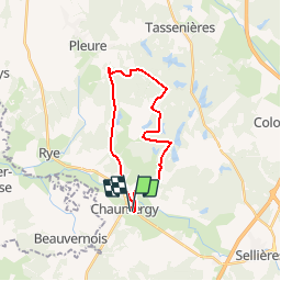
Tour Mountainbike von 21 km verfügbar auf Burgund und Freigrafschaft, Jura, Chaumergy. Diese Tour wird von tracegps vorgeschlagen.
Beschreibung
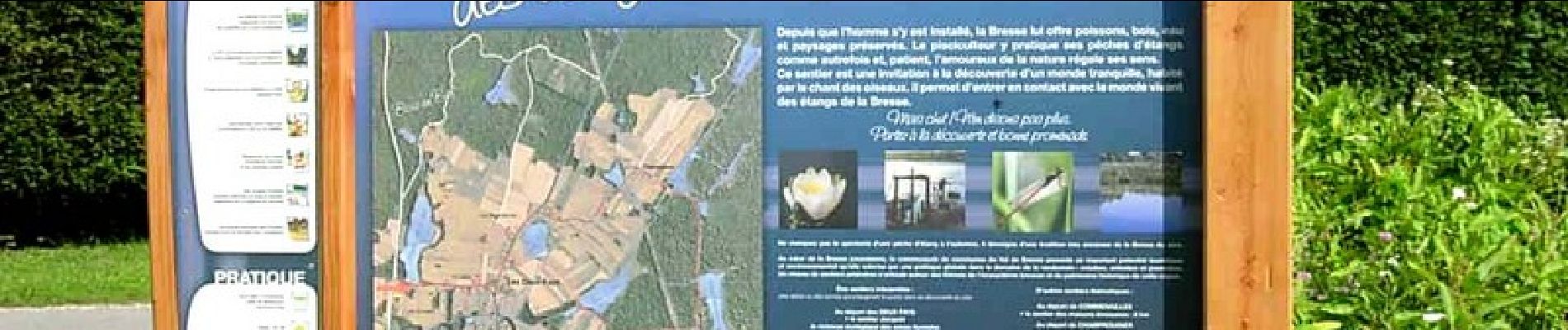
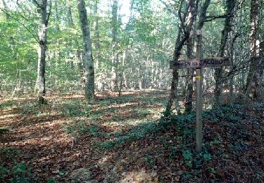
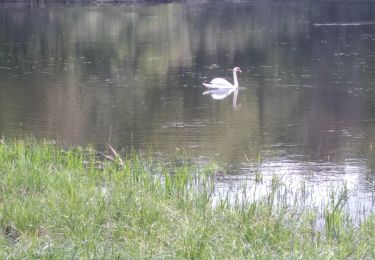
Circuit de 21 km à travers les étangs de la Bresse jurassienne empruntant des chemins blancs de l’ancienne voie ferrée.
Ort
Land:
France
Region :
Burgund und Freigrafschaft
Abteilung/Provinz :
Jura
Kommune :
Chaumergy
Standort:
Unknown
Gehen Sie:(Dec)
Gehen Sie:(UTM)
689282 ; 5191027 (31T) N.
Kommentare
Touren in der Umgebung
![Tour Zu Fuß Les Deux-Fays - Circuits des 19 Etangs - Photo](https://media.geolcdn.com/t/375/260/ext.jpg?maxdim=2&url=https%3A%2F%2Fmedia.geolcdn.com%2Ff%2F50d427ae-feed-4f46-8668-ae85cbe76d54.jpeg)
![Zu Fuß Zu Fuß](https://static1.geolcdn.com/sitytour/trail-icons/100.png)
Circuits des 19 Etangs
Zu Fuß
Einfach
Les Deux-Fays,
Burgund und Freigrafschaft,
Jura,
France
![](/images/other/stat-length.png)
8,3 km | 9,3 km-effort
2h 7min
![](https://static1.geolcdn.com/siteimages/upload/files/16400158638029165_repeat_loop_refresh_sync_direction_icon.png)
Nein
![Tour Wandern Vers-sous-Sellières - f)Etapa 6 - Photo](https://media.geolcdn.com/t/375/260/ext.jpg?maxdim=2&url=https%3A%2F%2Fservices.sitytrail.com%2FGeolivesWS%2FDownloadMedia.ashx%3FTrailID%3D711079%26Media%3D20170306101034.jpg)
![Wandern Wandern](https://static1.geolcdn.com/sitytour/trail-icons/101.png)
f)Etapa 6
Wandern
Medium
Vers-sous-Sellières,
Burgund und Freigrafschaft,
Jura,
France
![](/images/other/stat-length.png)
30 km | 33 km-effort
4h 0min
![](https://static1.geolcdn.com/siteimages/upload/files/16400158638029165_repeat_loop_refresh_sync_direction_icon.png)
Nein
![Tour Wandern Sergenaux - Sentier Jacquot - Photo](https://media.geolcdn.com/t/375/260/ext.jpg?maxdim=2&url=https%3A%2F%2Fservices.sitytrail.com%2FGeolivesWS%2FDownloadMedia.ashx%3FTrailID%3D357386%26Media%3Dfix__20141026143753.jpg)
![Wandern Wandern](https://static1.geolcdn.com/sitytour/trail-icons/101.png)
Sentier Jacquot
Wandern
Sehr leicht
Sergenaux,
Burgund und Freigrafschaft,
Jura,
France
![](/images/other/stat-length.png)
6,2 km | 7,1 km-effort
2h 23min
![](https://static1.geolcdn.com/siteimages/upload/files/16400158638029165_repeat_loop_refresh_sync_direction_icon.png)
Ja
![Tour Wandern Champrougier - Champrougier - Photo](https://media.geolcdn.com/t/375/260/ext.jpg?maxdim=2&url=https%3A%2F%2Fmedia.geolcdn.com%2Ff%2Fc8f9cb36-e993-46d8-b9b9-7bb265df4e23.jpg)
![Wandern Wandern](https://static1.geolcdn.com/sitytour/trail-icons/101.png)
Champrougier
Wandern
Sehr leicht
Champrougier,
Burgund und Freigrafschaft,
Jura,
France
![](/images/other/stat-length.png)
22 km | 25 km-effort
5h 35min
![](https://static1.geolcdn.com/siteimages/upload/files/16400158638029165_repeat_loop_refresh_sync_direction_icon.png)
Ja
![Tour Zu Fuß Les Deux-Fays - PR sentier des Étangs 7 km - Photo](https://media.geolcdn.com/t/375/260/ext.jpg?maxdim=2&url=https%3A%2F%2Fstatic1.geolcdn.com%2Fsiteimages%2Fupload%2Ffiles%2F1545311037marcheuse_200dpi.jpg)
![Zu Fuß Zu Fuß](https://static1.geolcdn.com/sitytour/trail-icons/100.png)
PR sentier des Étangs 7 km
Zu Fuß
Einfach
Les Deux-Fays,
Burgund und Freigrafschaft,
Jura,
France
![](/images/other/stat-length.png)
5,8 km | 6,5 km-effort
1h 29min
![](https://static1.geolcdn.com/siteimages/upload/files/16400158638029165_repeat_loop_refresh_sync_direction_icon.png)
Nein
![Tour Wandern Commenailles - commenailles - Photo](https://media.geolcdn.com/t/375/260/ext.jpg?maxdim=2&url=https%3A%2F%2Fstatic1.geolcdn.com%2Fsiteimages%2Fupload%2Ffiles%2F1553511878bg_sport_marche.png)
![Wandern Wandern](https://static1.geolcdn.com/sitytour/trail-icons/101.png)
commenailles
Wandern
Einfach
Commenailles,
Burgund und Freigrafschaft,
Jura,
France
![](/images/other/stat-length.png)
18,7 km | 22 km-effort
5h 44min
![](https://static1.geolcdn.com/siteimages/upload/files/16400158638029165_repeat_loop_refresh_sync_direction_icon.png)
Ja
![Tour Wandern Commenailles - Etangs de la Bresse - Photo](https://media.geolcdn.com/t/375/260/ext.jpg?maxdim=2&url=https%3A%2F%2Fstatic1.geolcdn.com%2Fsiteimages%2Fupload%2Ffiles%2F1553511878bg_sport_marche.png)
![Wandern Wandern](https://static1.geolcdn.com/sitytour/trail-icons/101.png)
Etangs de la Bresse
Wandern
Sehr leicht
Commenailles,
Burgund und Freigrafschaft,
Jura,
France
![](/images/other/stat-length.png)
16,9 km | 19,6 km-effort
4h 18min
![](https://static1.geolcdn.com/siteimages/upload/files/16400158638029165_repeat_loop_refresh_sync_direction_icon.png)
Ja
![Tour Wandern Sergenaux - serveneaux - Photo](https://media.geolcdn.com/t/375/260/ext.jpg?maxdim=2&url=https%3A%2F%2Fstatic1.geolcdn.com%2Fsiteimages%2Fupload%2Ffiles%2F1553511878bg_sport_marche.png)
![Wandern Wandern](https://static1.geolcdn.com/sitytour/trail-icons/101.png)
serveneaux
Wandern
Sehr schwierig
Sergenaux,
Burgund und Freigrafschaft,
Jura,
France
![](/images/other/stat-length.png)
17,1 km | 19,5 km-effort
4h 51min
![](https://static1.geolcdn.com/siteimages/upload/files/16400158638029165_repeat_loop_refresh_sync_direction_icon.png)
Ja
![Tour Wandern Commenailles - Commenaille 18.7km 20201015 - Photo](https://media.geolcdn.com/t/375/260/ext.jpg?maxdim=2&url=https%3A%2F%2Fstatic1.geolcdn.com%2Fsiteimages%2Fupload%2Ffiles%2F1553511878bg_sport_marche.png)
![Wandern Wandern](https://static1.geolcdn.com/sitytour/trail-icons/101.png)
Commenaille 18.7km 20201015
Wandern
Sehr leicht
Commenailles,
Burgund und Freigrafschaft,
Jura,
France
![](/images/other/stat-length.png)
18,9 km | 22 km-effort
4h 20min
![](https://static1.geolcdn.com/siteimages/upload/files/16400158638029165_repeat_loop_refresh_sync_direction_icon.png)
Ja