![](/images/other/stat-length.png)
![Tour Wandern Massérac - Circuit des Marais - Massérac - Photo](https://media.geolcdn.com/t/1900/400/ext.pjpeg?maxdim=2&url=https%3A%2F%2Fservices.sitytrail.com%2FGeolivesWS%2FDownloadMedia.ashx%3FTrailID%3D111720%26Media%3D8046_4.jpg)
Circuit des Marais - Massérac
tracegps
Benutzer
![Länge](/images/other/stat-length.png)
Länge
15,3 km
![Maximale Höhe](https://static1.geolcdn.com/siteimages/upload/files/1508320355ic_sort_altitude_max_24dp.png)
Maximale Höhe
34 m
![Positive Höhendifferenz](https://static1.geolcdn.com/siteimages/upload/files/1508320355ic_sort_den_pos_24dp.png)
Positive Höhendifferenz
122 m
![Km-Effort](/images/other/stat-length.png)
Km-Effort
16,9 km
![Min. Höhe](https://static1.geolcdn.com/siteimages/upload/files/1508320355ic_sort_altitude_min_24dp.png)
Min. Höhe
-2 m
![Negative Höhendifferenz](https://static1.geolcdn.com/siteimages/upload/files/1508320355ic_sort_den_neg_24dp.png)
Negative Höhendifferenz
122 m
![Boucle](https://static1.geolcdn.com/siteimages/upload/files/16400158638029165_repeat_loop_refresh_sync_direction_icon.png)
Boucle
Ja
Erstellungsdatum :
2014-12-10 00:00:00.0
Letzte Änderung :
2014-12-10 00:00:00.0
![Wandern](https://static1.geolcdn.com/sitytour/trail-icons/101.png)
3h49
Schwierigkeit : Schwierig
![Scannen Sie diesen QR-Code, um die Tour in der SityTrail-Anwendung zu öffnen](https://capi.geolives.com/qq0zvz2zws4bq2lad0pu/sitytour/trails/111720/qr.png?size=200)
Kostenlosegpshiking-Anwendung
Über SityTrail
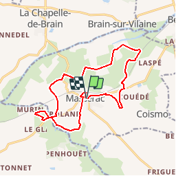
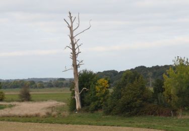
Tour Wandern von 15,3 km verfügbar auf Pays de la Loire, Loire-Atlantique, Massérac. Diese Tour wird von tracegps vorgeschlagen.
Beschreibung
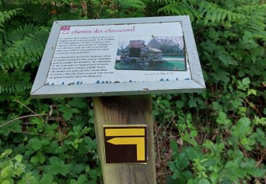
Circuit proposé par la maison du tourisme du Pays de Redon . Départ de l’église. Retrouvez ICI le circuit sur le site du Pays de Redon.
Ort
Land:
France
Region :
Pays de la Loire
Abteilung/Provinz :
Loire-Atlantique
Kommune :
Massérac
Standort:
Unknown
Gehen Sie:(Dec)
Gehen Sie:(UTM)
581561 ; 5280482 (30T) N.
Kommentare
Touren in der Umgebung
![Tour Wandern La Chapelle-de-Brain - Crêtes et Rivière - La Chapelle de Brain - Photo](https://media.geolcdn.com/t/375/260/ext.jpg?maxdim=2&url=https%3A%2F%2Fservices.sitytrail.com%2FGeolivesWS%2FDownloadMedia.ashx%3FTrailID%3D317661%26Media%3D16948_4.jpg)
![Wandern Wandern](https://static1.geolcdn.com/sitytour/trail-icons/101.png)
Crêtes et Rivière - La Chapelle de Brain
Wandern
Medium
(1)
La Chapelle-de-Brain,
Bretagne,
Ille-et-Vilaine,
France
![](/images/other/stat-length.png)
12,6 km | 15,1 km-effort
3h 10min
![](https://static1.geolcdn.com/siteimages/upload/files/16400158638029165_repeat_loop_refresh_sync_direction_icon.png)
Ja
![Tour Wandern La Chapelle-de-Brain - Circuit des rivières et des marais - La Chapelle-de-Brain - Photo](https://media.geolcdn.com/t/375/260/ext.jpg?maxdim=2&url=https%3A%2F%2Fservices.sitytrail.com%2FGeolivesWS%2FDownloadMedia.ashx%3FTrailID%3D112242%26Media%3D10171_3.jpg)
![Wandern Wandern](https://static1.geolcdn.com/sitytour/trail-icons/101.png)
Circuit des rivières et des marais - La Chapelle-de-Brain
Wandern
Schwierig
La Chapelle-de-Brain,
Bretagne,
Ille-et-Vilaine,
France
![](/images/other/stat-length.png)
14,1 km | 15,9 km-effort
3h 30min
![](https://static1.geolcdn.com/siteimages/upload/files/16400158638029165_repeat_loop_refresh_sync_direction_icon.png)
Ja
![Tour Wandern Guémené-Penfao - Circuit de l'île de Beslé - Beslé sur Vilaine - Photo](https://media.geolcdn.com/t/375/260/ext.jpg?maxdim=2&url=https%3A%2F%2Fservices.sitytrail.com%2FGeolivesWS%2FDownloadMedia.ashx%3FTrailID%3D111734%26Media%3D8118_1.jpg)
![Wandern Wandern](https://static1.geolcdn.com/sitytour/trail-icons/101.png)
Circuit de l'île de Beslé - Beslé sur Vilaine
Wandern
Einfach
Guémené-Penfao,
Pays de la Loire,
Loire-Atlantique,
France
![](/images/other/stat-length.png)
7,3 km | 8,3 km-effort
1h 45min
![](https://static1.geolcdn.com/siteimages/upload/files/16400158638029165_repeat_loop_refresh_sync_direction_icon.png)
Ja
![Tour Wandern Avessac - 190- les 2 rives par Painfaut - Photo](https://media.geolcdn.com/t/375/260/ext.jpg?maxdim=2&url=https%3A%2F%2Fmedia.geolcdn.com%2Ff%2F3b903a05-a335-4865-8779-e18d44ba0b2f.jpg)
![Wandern Wandern](https://static1.geolcdn.com/sitytour/trail-icons/101.png)
190- les 2 rives par Painfaut
Wandern
Einfach
Avessac,
Pays de la Loire,
Loire-Atlantique,
France
![](/images/other/stat-length.png)
14,7 km | 16,3 km-effort
3h 24min
![](https://static1.geolcdn.com/siteimages/upload/files/16400158638029165_repeat_loop_refresh_sync_direction_icon.png)
Ja
![Tour Wandern Guémené-Penfao - BRAIN SUR VILAINE / LA CHAPELLE DE BRAIN 14/05/2022 - Photo](https://media.geolcdn.com/t/375/260/ext.jpg?maxdim=2&url=https%3A%2F%2Fmedia.geolcdn.com%2Ff%2Fe1e4a3ab-ef36-4387-9203-5a1cd6ca2c15.jpg)
![Wandern Wandern](https://static1.geolcdn.com/sitytour/trail-icons/101.png)
BRAIN SUR VILAINE / LA CHAPELLE DE BRAIN 14/05/2022
Wandern
Medium
Guémené-Penfao,
Pays de la Loire,
Loire-Atlantique,
France
![](/images/other/stat-length.png)
19,8 km | 23 km-effort
6h 27min
![](https://static1.geolcdn.com/siteimages/upload/files/16400158638029165_repeat_loop_refresh_sync_direction_icon.png)
Ja
![Tour Nordic Walking Guémené-Penfao - lavoir, forage de l’étier - Photo](https://media.geolcdn.com/t/375/260/ext.jpg?maxdim=2&url=https%3A%2F%2Fstatic1.geolcdn.com%2Fsiteimages%2Fupload%2Ffiles%2F1545311037marcheuse_200dpi.jpg)
![Nordic Walking Nordic Walking](https://static1.geolcdn.com/sitytour/trail-icons/102.png)
lavoir, forage de l’étier
Nordic Walking
Guémené-Penfao,
Pays de la Loire,
Loire-Atlantique,
France
![](/images/other/stat-length.png)
11,9 km | 12,8 km-effort
2h 14min
![](https://static1.geolcdn.com/siteimages/upload/files/16400158638029165_repeat_loop_refresh_sync_direction_icon.png)
Ja
![Tour Wandern Avessac - Avessac 5 km - Photo](https://media.geolcdn.com/t/375/260/ext.jpg?maxdim=2&url=https%3A%2F%2Fstatic1.geolcdn.com%2Fsiteimages%2Fupload%2Ffiles%2F1553511878bg_sport_marche.png)
![Wandern Wandern](https://static1.geolcdn.com/sitytour/trail-icons/101.png)
Avessac 5 km
Wandern
Einfach
Avessac,
Pays de la Loire,
Loire-Atlantique,
France
![](/images/other/stat-length.png)
5,1 km | 5,7 km-effort
1h 40min
![](https://static1.geolcdn.com/siteimages/upload/files/16400158638029165_repeat_loop_refresh_sync_direction_icon.png)
Ja
![Tour Wandern Guémené-Penfao - Circuit de l'ile de Beslé - GUEMENE-PENFAO - Photo](https://media.geolcdn.com/t/375/260/ext.jpg?maxdim=2&url=https%3A%2F%2Fstatic1.geolcdn.com%2Fsiteimages%2Fupload%2Ffiles%2F1553511878bg_sport_marche.png)
![Wandern Wandern](https://static1.geolcdn.com/sitytour/trail-icons/101.png)
Circuit de l'ile de Beslé - GUEMENE-PENFAO
Wandern
Einfach
Guémené-Penfao,
Pays de la Loire,
Loire-Atlantique,
France
![](/images/other/stat-length.png)
7,2 km | 8,3 km-effort
1h 52min
![](https://static1.geolcdn.com/siteimages/upload/files/16400158638029165_repeat_loop_refresh_sync_direction_icon.png)
Ja
![Tour Wandern La Chapelle-de-Brain - Circuit des rivières et des marais - La Chapelle-de-Brain - Photo](https://media.geolcdn.com/t/375/260/ext.jpg?maxdim=2&url=https%3A%2F%2Fstatic1.geolcdn.com%2Fsiteimages%2Fupload%2Ffiles%2F1553511878bg_sport_marche.png)
![Wandern Wandern](https://static1.geolcdn.com/sitytour/trail-icons/101.png)
Circuit des rivières et des marais - La Chapelle-de-Brain
Wandern
Schwierig
La Chapelle-de-Brain,
Bretagne,
Ille-et-Vilaine,
France
![](/images/other/stat-length.png)
14,1 km | 15,9 km-effort
3h 30min
![](https://static1.geolcdn.com/siteimages/upload/files/16400158638029165_repeat_loop_refresh_sync_direction_icon.png)
Ja