![](/images/other/stat-length.png)
![Tour Wandern Belfort - Rando-les hauts de belfort - Photo](https://media.geolcdn.com/t/1900/400/ext.pjpeg?maxdim=2&url=https%3A%2F%2Fservices.sitytrail.com%2FGeolivesWS%2FDownloadMedia.ashx%3FTrailID%3D154479%26Media%3D58458d5d-9d29-4bf6-a3f8-9707461fc49e.jpg)
Rando-les hauts de belfort
benoit747
Benutzer
![Länge](/images/other/stat-length.png)
Länge
9,4 km
![Maximale Höhe](https://static1.geolcdn.com/siteimages/upload/files/1508320355ic_sort_altitude_max_24dp.png)
Maximale Höhe
450 m
![Positive Höhendifferenz](https://static1.geolcdn.com/siteimages/upload/files/1508320355ic_sort_den_pos_24dp.png)
Positive Höhendifferenz
169 m
![Km-Effort](/images/other/stat-length.png)
Km-Effort
11,6 km
![Min. Höhe](https://static1.geolcdn.com/siteimages/upload/files/1508320355ic_sort_altitude_min_24dp.png)
Min. Höhe
358 m
![Negative Höhendifferenz](https://static1.geolcdn.com/siteimages/upload/files/1508320355ic_sort_den_neg_24dp.png)
Negative Höhendifferenz
167 m
![Boucle](https://static1.geolcdn.com/siteimages/upload/files/16400158638029165_repeat_loop_refresh_sync_direction_icon.png)
Boucle
Ja
Erstellungsdatum :
2014-12-10 00:00:00.0
Letzte Änderung :
2018-12-03 10:08:54.079
![Wandern](https://static1.geolcdn.com/sitytour/trail-icons/101.png)
2h00
Schwierigkeit : Einfach
![Scannen Sie diesen QR-Code, um die Tour in der SityTrail-Anwendung zu öffnen](https://capi.geolives.com/qq0zvz2zws4bq2lad0pu/sitytour/trails/154479/qr.png?size=200)
Kostenlosegpshiking-Anwendung
Über SityTrail
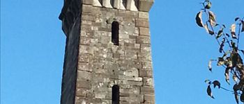
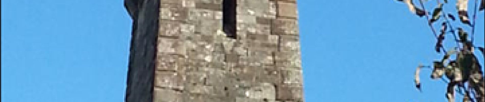
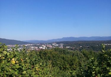
Tour Wandern von 9,4 km verfügbar auf Burgund und Freigrafschaft, Territoire-de-Belfort, Belfort. Diese Tour wird von benoit747 vorgeschlagen.
Beschreibung
rando balisée rond vert, rectangle jaune.
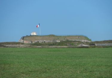
Une ballade sympa sur une demi journée qui vous permettra de découvrir les fortifications de Belfort
Ort
Land:
France
Region :
Burgund und Freigrafschaft
Abteilung/Provinz :
Territoire-de-Belfort
Kommune :
Belfort
Standort:
Unknown
Gehen Sie:(Dec)
Gehen Sie:(UTM)
339628 ; 5279886 (32T) N.
Kommentare
Touren in der Umgebung
![Tour Wandern Belfort - Offemont - La ballade des Champs Cerisiers - Photo](https://media.geolcdn.com/t/375/260/ext.jpg?maxdim=2&url=https%3A%2F%2Fstatic1.geolcdn.com%2Fsiteimages%2Fupload%2Ffiles%2F1553511878bg_sport_marche.png)
![Wandern Wandern](https://static1.geolcdn.com/sitytour/trail-icons/101.png)
Offemont - La ballade des Champs Cerisiers
Wandern
Einfach
(1)
Belfort,
Burgund und Freigrafschaft,
Territoire-de-Belfort,
France
![](/images/other/stat-length.png)
8,8 km | 10,8 km-effort
Unbekannt
![](https://static1.geolcdn.com/siteimages/upload/files/16400158638029165_repeat_loop_refresh_sync_direction_icon.png)
Ja
![Tour Wandern Sermamagny - Veronne PC - Photo](https://media.geolcdn.com/t/375/260/ext.jpg?maxdim=2&url=https%3A%2F%2Fstatic1.geolcdn.com%2Fsiteimages%2Fupload%2Ffiles%2F1553511878bg_sport_marche.png)
![Wandern Wandern](https://static1.geolcdn.com/sitytour/trail-icons/101.png)
Veronne PC
Wandern
Sehr leicht
(2)
Sermamagny,
Burgund und Freigrafschaft,
Territoire-de-Belfort,
France
![](/images/other/stat-length.png)
8,1 km | 9 km-effort
1h 59min
![](https://static1.geolcdn.com/siteimages/upload/files/16400158638029165_repeat_loop_refresh_sync_direction_icon.png)
Ja
![Tour Zu Fuß Offemundt - Sentier de la Roselière - Photo](https://media.geolcdn.com/t/375/260/ext.jpg?maxdim=2&url=https%3A%2F%2Fmedia.geolcdn.com%2Ff%2Fc8e60aaf-8ba5-407b-b750-77a1aea99966.jpeg)
![Zu Fuß Zu Fuß](https://static1.geolcdn.com/sitytour/trail-icons/100.png)
Sentier de la Roselière
Zu Fuß
Einfach
Offemundt,
Burgund und Freigrafschaft,
Territoire-de-Belfort,
France
![](/images/other/stat-length.png)
3,9 km | 4,3 km-effort
58min
![](https://static1.geolcdn.com/siteimages/upload/files/16400158638029165_repeat_loop_refresh_sync_direction_icon.png)
Ja
![Tour Mountainbike Wieswald - 1er tour avec Olivier - Photo](https://media.geolcdn.com/t/375/260/ext.jpg?maxdim=2&url=https%3A%2F%2Fstatic1.geolcdn.com%2Fsiteimages%2Fupload%2Ffiles%2F1524743154velo.jpg)
![Mountainbike Mountainbike](https://static1.geolcdn.com/sitytour/trail-icons/202.png)
1er tour avec Olivier
Mountainbike
Einfach
(1)
Wieswald,
Burgund und Freigrafschaft,
Territoire-de-Belfort,
France
![](/images/other/stat-length.png)
38 km | 47 km-effort
2h 59min
![](https://static1.geolcdn.com/siteimages/upload/files/16400158638029165_repeat_loop_refresh_sync_direction_icon.png)
Ja
![Tour Wandern Schert - Essert - Petit Salbert - Photo](https://media.geolcdn.com/t/375/260/ext.jpg?maxdim=2&url=https%3A%2F%2Fstatic1.geolcdn.com%2Fsiteimages%2Fupload%2Ffiles%2F1553511878bg_sport_marche.png)
![Wandern Wandern](https://static1.geolcdn.com/sitytour/trail-icons/101.png)
Essert - Petit Salbert
Wandern
Sehr leicht
(1)
Schert,
Burgund und Freigrafschaft,
Territoire-de-Belfort,
France
![](/images/other/stat-length.png)
7,4 km | 10,2 km-effort
2h 10min
![](https://static1.geolcdn.com/siteimages/upload/files/16400158638029165_repeat_loop_refresh_sync_direction_icon.png)
Ja
![Tour Mountainbike Belfort - tour de la miotte Blingarno - Photo](https://media.geolcdn.com/t/375/260/ext.jpg?maxdim=2&url=https%3A%2F%2Fservices.sitytrail.com%2FGeolivesWS%2FDownloadMedia.ashx%3FTrailID%3D219178%26Media%3Dfix__20130905100532.jpg)
![Mountainbike Mountainbike](https://static1.geolcdn.com/sitytour/trail-icons/202.png)
tour de la miotte Blingarno
Mountainbike
Medium
Belfort,
Burgund und Freigrafschaft,
Territoire-de-Belfort,
France
![](/images/other/stat-length.png)
10,5 km | 12,4 km-effort
52min
![](https://static1.geolcdn.com/siteimages/upload/files/16400158638029165_repeat_loop_refresh_sync_direction_icon.png)
Ja
![Tour Mountainbike Belfort - Transterritoire de Belfort 2011 - Photo](https://media.geolcdn.com/t/375/260/ext.jpg?maxdim=2&url=https%3A%2F%2Fservices.sitytrail.com%2FGeolivesWS%2FDownloadMedia.ashx%3FTrailID%3D107302%26Media%3D12189_3.jpg)
![Mountainbike Mountainbike](https://static1.geolcdn.com/sitytour/trail-icons/202.png)
Transterritoire de Belfort 2011
Mountainbike
Schwierig
Belfort,
Burgund und Freigrafschaft,
Territoire-de-Belfort,
France
![](/images/other/stat-length.png)
71 km | 91 km-effort
5h 0min
![](https://static1.geolcdn.com/siteimages/upload/files/16400158638029165_repeat_loop_refresh_sync_direction_icon.png)
Ja
![Tour Wandern Belfort - Marche JO Belfort Couthenans - Photo](https://media.geolcdn.com/t/375/260/ext.jpg?maxdim=2&url=https%3A%2F%2Fmedia.geolcdn.com%2Ff%2Fd246e445-c7ff-456a-b226-480813c20fde.jpg)
![Wandern Wandern](https://static1.geolcdn.com/sitytour/trail-icons/101.png)
Marche JO Belfort Couthenans
Wandern
Schwierig
Belfort,
Burgund und Freigrafschaft,
Territoire-de-Belfort,
France
![](/images/other/stat-length.png)
19,1 km | 23 km-effort
5h 19min
![](https://static1.geolcdn.com/siteimages/upload/files/16400158638029165_repeat_loop_refresh_sync_direction_icon.png)
Nein
![Tour Wandern Sermamagny - Le Malsaucy - Photo](https://media.geolcdn.com/t/375/260/ext.jpg?maxdim=2&url=https%3A%2F%2Fmedia.geolcdn.com%2Ff%2Fdf269a02-71ec-4294-be05-22a6be035359.jpg)
![Wandern Wandern](https://static1.geolcdn.com/sitytour/trail-icons/101.png)
Le Malsaucy
Wandern
Sehr leicht
Sermamagny,
Burgund und Freigrafschaft,
Territoire-de-Belfort,
France
![](/images/other/stat-length.png)
9,7 km | 11,2 km-effort
2h 10min
![](https://static1.geolcdn.com/siteimages/upload/files/16400158638029165_repeat_loop_refresh_sync_direction_icon.png)
Ja