Randonnee-Pic-de-Carlit-2921m-Mariano-le-09-09-2013

UDGI54
Benutzer

Länge
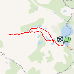
13,4 km

Maximale Höhe
2885 m

Positive Höhendifferenz
889 m
Km-Effort
25 km

Min. Höhe
2038 m

Negative Höhendifferenz
887 m
Boucle
Ja
Erstellungsdatum :
2019-06-11 07:21:55.866
Letzte Änderung :
2019-06-11 07:26:31.929
5h04
Schwierigkeit : Sehr schwierig

Kostenlosegpshiking-Anwendung
 SityTrail
IGN / Geografische Institute
SityTrail Plus
Die Welt öffnet sich für Sie
Über SityTrail
Tour Wandern von 13,4 km verfügbar auf Okzitanien, Ostpyrenäen, Angoustrine-Villeneuve-des-Escaldes. Diese Tour wird von UDGI54 vorgeschlagen.
POIs


Ort
Land:
France
Region :
Okzitanien
Abteilung/Provinz :
Ostpyrenäen
Kommune :
Angoustrine-Villeneuve-des-Escaldes
Standort:
Unknown
Gehen Sie:(Dec)
Gehen Sie:(UTM)
417598 ; 4712439 (31T) N.
Kommentare