


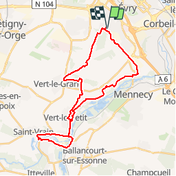
VERT LE GRAND ETANGS LISSES

ALIROL
Benutzer

Länge
32 km

Maximale Höhe
97 m

Positive Höhendifferenz
283 m
Km-Effort
36 km

Min. Höhe
45 m

Negative Höhendifferenz
283 m
Boucle
Ja
Erstellungsdatum :
2014-12-10 00:00:00.0
Letzte Änderung :
2014-12-10 00:00:00.0
2h22
Schwierigkeit : Medium

Kostenlosegpshiking-Anwendung
 SityTrail
IGN / Geografische Institute
SityTrail Plus
Die Welt öffnet sich für Sie
Über SityTrail
Tour Mountainbike von 32 km verfügbar auf Île-de-France, Essonne, Évry-Courcouronnes. Diese Tour wird von ALIROL vorgeschlagen.
Beschreibung
Chemins. Très peu de routes.
Ort
Land:
France
Region :
Île-de-France
Abteilung/Provinz :
Essonne
Kommune :
Évry-Courcouronnes
Standort:
Courcouronnes
Gehen Sie:(Dec)
Gehen Sie:(UTM)
456402 ; 5384362 (31U) N.
Kommentare