


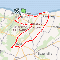
arromanches 17 kms 2019

aubinjoel
Benutzer

Länge
16,8 km

Maximale Höhe
58 m

Positive Höhendifferenz
189 m
Km-Effort
19,3 km

Min. Höhe
0 m

Negative Höhendifferenz
193 m
Boucle
Ja
Erstellungsdatum :
2019-10-01 15:02:47.46
Letzte Änderung :
2019-10-01 15:03:09.445

Kostenlosegpshiking-Anwendung
 SityTrail
IGN / Geografische Institute
SityTrail Plus
Die Welt öffnet sich für Sie
Über SityTrail
Tour von 16,8 km verfügbar auf Normandie, Calvados, Arromanches-les-Bains. Diese Tour wird von aubinjoel vorgeschlagen.
Ort
Land:
France
Region :
Normandie
Abteilung/Provinz :
Calvados
Kommune :
Arromanches-les-Bains
Standort:
Unknown
Gehen Sie:(Dec)
Gehen Sie:(UTM)
672607 ; 5467765 (30U) N.
Kommentare