![](/images/other/stat-length.png)
![Tour Wandern Pontcarré - Boucle en Forêts de Ferrières et d'Armanvilliers - Photo](https://media.geolcdn.com/t/1900/400/ext.pjpeg?maxdim=2&url=https%3A%2F%2Fmedia.geolcdn.com%2Ff%2Fb5b1dc99-a809-4ba1-bab8-4ef842e604ec.jpg)
Boucle en Forêts de Ferrières et d'Armanvilliers
Les 1000 pattes
Club randonnées SERVON
![Länge](/images/other/stat-length.png)
Länge
11,6 km
![Maximale Höhe](https://static1.geolcdn.com/siteimages/upload/files/1508320355ic_sort_altitude_max_24dp.png)
Maximale Höhe
128 m
![Positive Höhendifferenz](https://static1.geolcdn.com/siteimages/upload/files/1508320355ic_sort_den_pos_24dp.png)
Positive Höhendifferenz
74 m
![Km-Effort](/images/other/stat-length.png)
Km-Effort
12,6 km
![Min. Höhe](https://static1.geolcdn.com/siteimages/upload/files/1508320355ic_sort_altitude_min_24dp.png)
Min. Höhe
112 m
![Negative Höhendifferenz](https://static1.geolcdn.com/siteimages/upload/files/1508320355ic_sort_den_neg_24dp.png)
Negative Höhendifferenz
74 m
![Boucle](https://static1.geolcdn.com/siteimages/upload/files/16400158638029165_repeat_loop_refresh_sync_direction_icon.png)
Boucle
Ja
Erstellungsdatum :
2021-11-08 10:58:17.336
Letzte Änderung :
2021-11-13 16:04:54.589
![Wandern](https://static1.geolcdn.com/sitytour/trail-icons/101.png)
3h40
Schwierigkeit : Medium
![Scannen Sie diesen QR-Code, um die Tour in der SityTrail-Anwendung zu öffnen](https://capi.geolives.com/qq0zvz2zws4bq2lad0pu/sitytour/trails/2996119/qr.png?size=200)
Kostenlosegpshiking-Anwendung
Über SityTrail
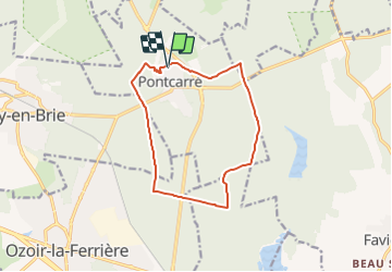
Tour Wandern von 11,6 km verfügbar auf Île-de-France, Seine-et-Marne, Pontcarré. Diese Tour wird von Les 1000 pattes vorgeschlagen.
Beschreibung
Parking Place Jean Moulin à Pontcarré (Mairie)
Trajet Servon-->Pontcarré (16km: 23mn
Ort
Land:
France
Region :
Île-de-France
Abteilung/Provinz :
Seine-et-Marne
Kommune :
Pontcarré
Standort:
Unknown
Gehen Sie:(Dec)
Gehen Sie:(UTM)
478274 ; 5405277 (31U) N.
Kommentare
Touren in der Umgebung
![Tour sport Jossigny - Carrefour de la Belle assise - Photo](https://media.geolcdn.com/t/375/260/ext.jpg?maxdim=2&url=https%3A%2F%2Fmedia.geolcdn.com%2Ff%2Faef1b2f5-eb67-4417-9d23-d09a0d22575a.jpg)
Carrefour de la Belle assise
sport
Sehr leicht
Jossigny,
Île-de-France,
Seine-et-Marne,
France
![](/images/other/stat-length.png)
4,3 km | 4,7 km-effort
Unbekannt
![](https://static1.geolcdn.com/siteimages/upload/files/16400158638029165_repeat_loop_refresh_sync_direction_icon.png)
Ja
![Tour Wandern Ferrières-en-Brie - allée des lions Ferrières en brie - Photo](https://media.geolcdn.com/t/375/260/ext.jpg?maxdim=2&url=https%3A%2F%2Fmedia.geolcdn.com%2Ff%2Fc37505e8-7264-4ccf-bd5a-b749d62d5806.jpg)
![Wandern Wandern](https://static1.geolcdn.com/sitytour/trail-icons/101.png)
allée des lions Ferrières en brie
Wandern
Einfach
Ferrières-en-Brie,
Île-de-France,
Seine-et-Marne,
France
![](/images/other/stat-length.png)
3,3 km | 3,8 km-effort
1h 0min
![](https://static1.geolcdn.com/siteimages/upload/files/16400158638029165_repeat_loop_refresh_sync_direction_icon.png)
Nein
![Tour Wandern Ozoir-la-Ferrière - OZOIR > BOISSY 18 KM - Photo](https://media.geolcdn.com/t/375/260/ext.jpg?maxdim=2&url=https%3A%2F%2Fstatic1.geolcdn.com%2Fsiteimages%2Fupload%2Ffiles%2F1553511878bg_sport_marche.png)
![Wandern Wandern](https://static1.geolcdn.com/sitytour/trail-icons/101.png)
OZOIR > BOISSY 18 KM
Wandern
Sehr leicht
(1)
Ozoir-la-Ferrière,
Île-de-France,
Seine-et-Marne,
France
![](/images/other/stat-length.png)
18,7 km | 20 km-effort
4h 14min
![](https://static1.geolcdn.com/siteimages/upload/files/16400158638029165_repeat_loop_refresh_sync_direction_icon.png)
Nein
![Tour Wandern Pontcarré - CRAB : De Férrières à Armainvilliers - Photo](https://media.geolcdn.com/t/375/260/ext.jpg?maxdim=2&url=https%3A%2F%2Fservices.sitytrail.com%2FGeolivesWS%2FDownloadMedia.ashx%3FTrailID%3D687950%26Media%3Dfix__20170122115428.jpg)
![Wandern Wandern](https://static1.geolcdn.com/sitytour/trail-icons/101.png)
CRAB : De Férrières à Armainvilliers
Wandern
Einfach
Pontcarré,
Île-de-France,
Seine-et-Marne,
France
![](/images/other/stat-length.png)
21 km | 23 km-effort
4h 5min
![](https://static1.geolcdn.com/siteimages/upload/files/16400158638029165_repeat_loop_refresh_sync_direction_icon.png)
Ja
![Tour Fahrrad Jossigny - La Brie Boisée - Photo](https://media.geolcdn.com/t/375/260/ext.jpg?maxdim=2&url=https%3A%2F%2Fservices.sitytrail.com%2FGeolivesWS%2FDownloadMedia.ashx%3FTrailID%3D615026%26Media%3Dc44ff0cf-4262-43f7-a1d1-a563d1103930.JPG)
![Fahrrad Fahrrad](https://static1.geolcdn.com/sitytour/trail-icons/200.png)
La Brie Boisée
Fahrrad
Einfach
Jossigny,
Île-de-France,
Seine-et-Marne,
France
![](/images/other/stat-length.png)
121 km | 132 km-effort
5h 0min
![](https://static1.geolcdn.com/siteimages/upload/files/16400158638029165_repeat_loop_refresh_sync_direction_icon.png)
Nein
![Tour Wandern Torcy - torcy Lagny - Photo](https://media.geolcdn.com/t/375/260/ext.jpg?maxdim=2&url=https%3A%2F%2Fstatic1.geolcdn.com%2Fsiteimages%2Fupload%2Ffiles%2F1553511878bg_sport_marche.png)
![Wandern Wandern](https://static1.geolcdn.com/sitytour/trail-icons/101.png)
torcy Lagny
Wandern
Medium
(1)
Torcy,
Île-de-France,
Seine-et-Marne,
France
![](/images/other/stat-length.png)
18,8 km | 21 km-effort
4h 34min
![](https://static1.geolcdn.com/siteimages/upload/files/16400158638029165_repeat_loop_refresh_sync_direction_icon.png)
Ja
![Tour Wandern Favières - ballade - Photo](https://media.geolcdn.com/t/375/260/ext.jpg?maxdim=2&url=https%3A%2F%2Fservices.sitytrail.com%2FGeolivesWS%2FDownloadMedia.ashx%3FTrailID%3D189210%26Media%3D20130505131941.jpg)
![Wandern Wandern](https://static1.geolcdn.com/sitytour/trail-icons/101.png)
ballade
Wandern
Sehr leicht
Favières,
Île-de-France,
Seine-et-Marne,
France
![](/images/other/stat-length.png)
6,7 km | 7,4 km-effort
1h 32min
![](https://static1.geolcdn.com/siteimages/upload/files/16400158638029165_repeat_loop_refresh_sync_direction_icon.png)
Ja
![Tour Wandern Pontcarré - les lions de Ferrières - Photo](https://media.geolcdn.com/t/375/260/ext.jpg?maxdim=2&url=https%3A%2F%2Fservices.sitytrail.com%2FGeolivesWS%2FDownloadMedia.ashx%3FTrailID%3D180232%26Media%3D20130317144822.jpg)
![Wandern Wandern](https://static1.geolcdn.com/sitytour/trail-icons/101.png)
les lions de Ferrières
Wandern
Sehr leicht
Pontcarré,
Île-de-France,
Seine-et-Marne,
France
![](/images/other/stat-length.png)
3,1 km | 3,5 km-effort
40min
![](https://static1.geolcdn.com/siteimages/upload/files/16400158638029165_repeat_loop_refresh_sync_direction_icon.png)
Ja
![Tour Wandern Roissy-en-Brie - Rand'Oxygene - Photo](https://media.geolcdn.com/t/375/260/ext.jpg?maxdim=2&url=https%3A%2F%2Fmedia.geolcdn.com%2Ff%2Fafdc7928-bbf8-462b-b6df-f3c4d26b8729.jpg)
![Wandern Wandern](https://static1.geolcdn.com/sitytour/trail-icons/101.png)
Rand'Oxygene
Wandern
Medium
Roissy-en-Brie,
Île-de-France,
Seine-et-Marne,
France
![](/images/other/stat-length.png)
9,9 km | 10,8 km-effort
2h 27min
![](https://static1.geolcdn.com/siteimages/upload/files/16400158638029165_repeat_loop_refresh_sync_direction_icon.png)
Ja