![](/images/other/stat-length.png)
![Tour Zu Fuß Gent - Campagne wandeling - Photo](https://media.geolcdn.com/t/1900/400/ext.pjpeg?maxdim=2&url=https%3A%2F%2Fmedia.geolcdn.com%2Ff%2F3d89c286-67ac-4ed8-9d51-a3e73cef8982.jpeg)
Campagne wandeling
SityTrail - itinéraires balisés pédestres
Tous les sentiers balisés d’Europe PRO
![Länge](/images/other/stat-length.png)
Länge
7 km
![Maximale Höhe](https://static1.geolcdn.com/siteimages/upload/files/1508320355ic_sort_altitude_max_24dp.png)
Maximale Höhe
16 m
![Positive Höhendifferenz](https://static1.geolcdn.com/siteimages/upload/files/1508320355ic_sort_den_pos_24dp.png)
Positive Höhendifferenz
39 m
![Km-Effort](/images/other/stat-length.png)
Km-Effort
7,5 km
![Min. Höhe](https://static1.geolcdn.com/siteimages/upload/files/1508320355ic_sort_altitude_min_24dp.png)
Min. Höhe
-1 m
![Negative Höhendifferenz](https://static1.geolcdn.com/siteimages/upload/files/1508320355ic_sort_den_neg_24dp.png)
Negative Höhendifferenz
37 m
![Boucle](https://static1.geolcdn.com/siteimages/upload/files/16400158638029165_repeat_loop_refresh_sync_direction_icon.png)
Boucle
Ja
Kennzeichnung
Erstellungsdatum :
2022-02-09 19:24:20.896
Letzte Änderung :
2022-03-10 10:44:14.791
![Zu Fuß](https://static1.geolcdn.com/sitytour/trail-icons/100.png)
1h41
Schwierigkeit : Einfach
![Scannen Sie diesen QR-Code, um die Tour in der SityTrail-Anwendung zu öffnen](https://capi.geolives.com/qq0zvz2zws4bq2lad0pu/sitytour/trails/3085394/qr.png?size=200)
Kostenlosegpshiking-Anwendung
Über SityTrail
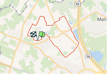
Tour Zu Fuß von 7 km verfügbar auf Flandern, Ostflandern, Gent. Diese Tour wird von SityTrail - itinéraires balisés pédestres vorgeschlagen.
Beschreibung
Trail created by Vlaamse landmaatschappij.
Symbol: triangle
Website: https://www.vlm.be/nl/groenpool-vinderhoutse-bossen
Ort
Land:
Belgium
Region :
Flandern
Abteilung/Provinz :
Ostflandern
Kommune :
Gent
Standort:
Drongen
Gehen Sie:(Dec)
Gehen Sie:(UTM)
546101 ; 5657155 (31U) N.
Kommentare
Touren in der Umgebung
![Tour Elektrofahrrad Gent - fietstocht 13-06-2021 sterretrappers - Photo](https://media.geolcdn.com/t/375/260/ext.jpg?maxdim=2&url=https%3A%2F%2Fmedia.geolcdn.com%2Ff%2Fc24dc209-7de8-4c69-b651-eeb4bc10b221.JPG)
![Elektrofahrrad Elektrofahrrad](https://static1.geolcdn.com/sitytour/trail-icons/205.png)
fietstocht 13-06-2021 sterretrappers
Elektrofahrrad
Sehr leicht
(1)
Gent,
Flandern,
Ostflandern,
Belgium
![](/images/other/stat-length.png)
33 km | 36 km-effort
Unbekannt
![](https://static1.geolcdn.com/siteimages/upload/files/16400158638029165_repeat_loop_refresh_sync_direction_icon.png)
Ja
![Tour Zu Fuß Gent - Door Luchteren en Oude Kale - Photo](https://media.geolcdn.com/t/375/260/ext.jpg?maxdim=2&url=https%3A%2F%2Fmedia.geolcdn.com%2Ff%2Fabded955-6a98-4333-a17f-cc251ab7d5c3.jpeg)
![Zu Fuß Zu Fuß](https://static1.geolcdn.com/sitytour/trail-icons/100.png)
Door Luchteren en Oude Kale
Zu Fuß
Einfach
Gent,
Flandern,
Ostflandern,
Belgium
![](/images/other/stat-length.png)
9,7 km | 10,4 km-effort
2h 21min
![](https://static1.geolcdn.com/siteimages/upload/files/16400158638029165_repeat_loop_refresh_sync_direction_icon.png)
Ja
![Tour Zu Fuß Gent - Vinderhoutse Bossen wandeling - Photo](https://media.geolcdn.com/t/375/260/ext.jpg?maxdim=2&url=https%3A%2F%2Fmedia.geolcdn.com%2Ff%2F572659ee-7cae-4b58-81f1-828035b8848e.jpeg)
![Zu Fuß Zu Fuß](https://static1.geolcdn.com/sitytour/trail-icons/100.png)
Vinderhoutse Bossen wandeling
Zu Fuß
Einfach
Gent,
Flandern,
Ostflandern,
Belgium
![](/images/other/stat-length.png)
9,8 km | 10,6 km-effort
2h 24min
![](https://static1.geolcdn.com/siteimages/upload/files/16400158638029165_repeat_loop_refresh_sync_direction_icon.png)
Ja
![Tour Zu Fuß Gent - Claeys-Boúúaert wandeling - Photo](https://media.geolcdn.com/t/375/260/ext.jpg?maxdim=2&url=https%3A%2F%2Fmedia.geolcdn.com%2Ff%2F921051f5-906e-47ac-b9c1-2a14046aee3f.jpeg)
![Zu Fuß Zu Fuß](https://static1.geolcdn.com/sitytour/trail-icons/100.png)
Claeys-Boúúaert wandeling
Zu Fuß
Einfach
Gent,
Flandern,
Ostflandern,
Belgium
![](/images/other/stat-length.png)
9,3 km | 10 km-effort
2h 15min
![](https://static1.geolcdn.com/siteimages/upload/files/16400158638029165_repeat_loop_refresh_sync_direction_icon.png)
Ja
![Tour Zu Fuß Gent - Leeuwenhof wandeling - Photo](https://media.geolcdn.com/t/375/260/ext.jpg?maxdim=2&url=https%3A%2F%2Fmedia.geolcdn.com%2Ff%2Fd9bc68bb-84e4-43b5-bfa1-638e3a2ebc41.jpeg)
![Zu Fuß Zu Fuß](https://static1.geolcdn.com/sitytour/trail-icons/100.png)
Leeuwenhof wandeling
Zu Fuß
Einfach
Gent,
Flandern,
Ostflandern,
Belgium
![](/images/other/stat-length.png)
4,4 km | 4,8 km-effort
1h 4min
![](https://static1.geolcdn.com/siteimages/upload/files/16400158638029165_repeat_loop_refresh_sync_direction_icon.png)
Ja
![Tour Zu Fuß Gent - Bourgoyen-Ossemeersen - Bourgoyenpad - Photo](https://media.geolcdn.com/t/375/260/ext.jpg?maxdim=2&url=https%3A%2F%2Fmedia.geolcdn.com%2Ff%2Fd0c2b3a9-5166-4f7a-9c9b-65fdd66fe07a.jpeg)
![Zu Fuß Zu Fuß](https://static1.geolcdn.com/sitytour/trail-icons/100.png)
Bourgoyen-Ossemeersen - Bourgoyenpad
Zu Fuß
Einfach
Gent,
Flandern,
Ostflandern,
Belgium
![](/images/other/stat-length.png)
5,1 km | 5,7 km-effort
1h 18min
![](https://static1.geolcdn.com/siteimages/upload/files/16400158638029165_repeat_loop_refresh_sync_direction_icon.png)
Ja
![Tour Zu Fuß Sint-Martens-Latem - Albijn Van Den Abeele Route - Photo](https://media.geolcdn.com/t/375/260/ext.jpg?maxdim=2&url=https%3A%2F%2Fmedia.geolcdn.com%2Ff%2Fbbfcb69d-666f-47bc-8c47-8c5c2ac7c6aa.jpeg)
![Zu Fuß Zu Fuß](https://static1.geolcdn.com/sitytour/trail-icons/100.png)
Albijn Van Den Abeele Route
Zu Fuß
Einfach
Sint-Martens-Latem,
Flandern,
Ostflandern,
Belgium
![](/images/other/stat-length.png)
8,3 km | 9 km-effort
2h 3min
![](https://static1.geolcdn.com/siteimages/upload/files/16400158638029165_repeat_loop_refresh_sync_direction_icon.png)
Ja
![Tour Zu Fuß Deinze - Oude Kalevallei - Lus 2 - Photo](https://media.geolcdn.com/t/375/260/ext.jpg?maxdim=2&url=https%3A%2F%2Fmedia.geolcdn.com%2Ff%2F9a68d079-d324-441f-ab36-1b80e1608fb1.jpeg)
![Zu Fuß Zu Fuß](https://static1.geolcdn.com/sitytour/trail-icons/100.png)
Oude Kalevallei - Lus 2
Zu Fuß
Einfach
Deinze,
Flandern,
Ostflandern,
Belgium
![](/images/other/stat-length.png)
3,7 km | 3,9 km-effort
53min
![](https://static1.geolcdn.com/siteimages/upload/files/16400158638029165_repeat_loop_refresh_sync_direction_icon.png)
Ja
![Tour Wandern Gent - Gand - Photo](https://media.geolcdn.com/t/375/260/ext.jpg?maxdim=2&url=https%3A%2F%2Fmedia.geolcdn.com%2Ff%2Fbecae5b4-1bd8-4ed9-a858-eb6535ae6c85.jpg)
![Wandern Wandern](https://static1.geolcdn.com/sitytour/trail-icons/101.png)
Gand
Wandern
Sehr leicht
Gent,
Flandern,
Ostflandern,
Belgium
![](/images/other/stat-length.png)
11,5 km | 12,5 km-effort
2h 40min
![](https://static1.geolcdn.com/siteimages/upload/files/16400158638029165_repeat_loop_refresh_sync_direction_icon.png)
Nein