![](/images/other/stat-length.png)
![Tour Wandern Épône - Balade du dimanche 10 avril 2022 - Photo](https://media.geolcdn.com/t/1900/400/ext.pjpeg?maxdim=2&url=https%3A%2F%2Fstatic1.geolcdn.com%2Fsiteimages%2Fupload%2Ffiles%2F1553511878bg_sport_marche.png)
Balade du dimanche 10 avril 2022
La balade du dimanche
![Länge](/images/other/stat-length.png)
Länge
11,5 km
![Maximale Höhe](https://static1.geolcdn.com/siteimages/upload/files/1508320355ic_sort_altitude_max_24dp.png)
Maximale Höhe
147 m
![Positive Höhendifferenz](https://static1.geolcdn.com/siteimages/upload/files/1508320355ic_sort_den_pos_24dp.png)
Positive Höhendifferenz
282 m
![Km-Effort](/images/other/stat-length.png)
Km-Effort
15,2 km
![Min. Höhe](https://static1.geolcdn.com/siteimages/upload/files/1508320355ic_sort_altitude_min_24dp.png)
Min. Höhe
25 m
![Negative Höhendifferenz](https://static1.geolcdn.com/siteimages/upload/files/1508320355ic_sort_den_neg_24dp.png)
Negative Höhendifferenz
281 m
![Boucle](https://static1.geolcdn.com/siteimages/upload/files/16400158638029165_repeat_loop_refresh_sync_direction_icon.png)
Boucle
Ja
Erstellungsdatum :
2022-04-10 08:32:39.0
Letzte Änderung :
2022-04-10 16:36:23.271
![Wandern](https://static1.geolcdn.com/sitytour/trail-icons/101.png)
2h43
Schwierigkeit : Einfach
![Scannen Sie diesen QR-Code, um die Tour in der SityTrail-Anwendung zu öffnen](https://capi.geolives.com/qq0zvz2zws4bq2lad0pu/sitytour/trails/3199051/qr.png?size=200)
Kostenlosegpshiking-Anwendung
Über SityTrail
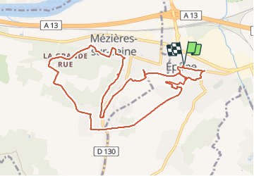
Tour Wandern von 11,5 km verfügbar auf Île-de-France, Yvelines, Épône. Diese Tour wird von La balade du dimanche vorgeschlagen.
Beschreibung
Balade au départ d'Épone vers la Villeneuve et retour par Mézières-sur-Seine
Ort
Land:
France
Region :
Île-de-France
Abteilung/Provinz :
Yvelines
Kommune :
Épône
Standort:
Unknown
Gehen Sie:(Dec)
Gehen Sie:(UTM)
413139 ; 5423427 (31U) N.
Kommentare
Touren in der Umgebung
![Tour Andere Aktivitäten Gargenville - parcourt FIFI - Photo](https://media.geolcdn.com/t/375/260/ext.jpg?maxdim=2&url=https%3A%2F%2Fstatic1.geolcdn.com%2Fsiteimages%2Fupload%2Ffiles%2F1545311037marcheuse_200dpi.jpg)
![Andere Aktivitäten Andere Aktivitäten](https://static1.geolcdn.com/sitytour/trail-icons/900.png)
parcourt FIFI
Andere Aktivitäten
Sehr leicht
(1)
Gargenville,
Île-de-France,
Yvelines,
France
![](/images/other/stat-length.png)
42 km | 46 km-effort
2h 49min
![](https://static1.geolcdn.com/siteimages/upload/files/16400158638029165_repeat_loop_refresh_sync_direction_icon.png)
Nein
![Tour Wandern La Falaise - Aulney sur Mauldre-La Falaise - Photo](https://media.geolcdn.com/t/375/260/ext.jpg?maxdim=2&url=https%3A%2F%2Fstatic1.geolcdn.com%2Fsiteimages%2Fupload%2Ffiles%2F1553511878bg_sport_marche.png)
![Wandern Wandern](https://static1.geolcdn.com/sitytour/trail-icons/101.png)
Aulney sur Mauldre-La Falaise
Wandern
Medium
(1)
La Falaise,
Île-de-France,
Yvelines,
France
![](/images/other/stat-length.png)
12,4 km | 15,9 km-effort
Unbekannt
![](https://static1.geolcdn.com/siteimages/upload/files/16400158638029165_repeat_loop_refresh_sync_direction_icon.png)
Ja
![Tour Wandern Épône - EPONES > MAREIL 15 KM - Photo](https://media.geolcdn.com/t/375/260/ext.jpg?maxdim=2&url=https%3A%2F%2Fstatic1.geolcdn.com%2Fsiteimages%2Fupload%2Ffiles%2F1553511878bg_sport_marche.png)
![Wandern Wandern](https://static1.geolcdn.com/sitytour/trail-icons/101.png)
EPONES > MAREIL 15 KM
Wandern
Sehr leicht
(1)
Épône,
Île-de-France,
Yvelines,
France
![](/images/other/stat-length.png)
14,7 km | 18,6 km-effort
3h 55min
![](https://static1.geolcdn.com/siteimages/upload/files/16400158638029165_repeat_loop_refresh_sync_direction_icon.png)
Nein
![Tour Wandern Aubergenville - petite balade autour du Gibouin - Photo](https://media.geolcdn.com/t/375/260/ext.jpg?maxdim=2&url=https%3A%2F%2Fservices.sitytrail.com%2FGeolivesWS%2FDownloadMedia.ashx%3FTrailID%3D255767%26Media%3D20140119115431.jpg)
![Wandern Wandern](https://static1.geolcdn.com/sitytour/trail-icons/101.png)
petite balade autour du Gibouin
Wandern
Sehr leicht
Aubergenville,
Île-de-France,
Yvelines,
France
![](/images/other/stat-length.png)
7,7 km | 8,2 km-effort
1h 45min
![](https://static1.geolcdn.com/siteimages/upload/files/16400158638029165_repeat_loop_refresh_sync_direction_icon.png)
Ja
![Tour Wandern Nézel - Nezel - Aulnay sur Mauldre - Photo](https://media.geolcdn.com/t/375/260/ext.jpg?maxdim=2&url=https%3A%2F%2Fstatic1.geolcdn.com%2Fsiteimages%2Fupload%2Ffiles%2F1553511878bg_sport_marche.png)
![Wandern Wandern](https://static1.geolcdn.com/sitytour/trail-icons/101.png)
Nezel - Aulnay sur Mauldre
Wandern
Einfach
(1)
Nézel,
Île-de-France,
Yvelines,
France
![](/images/other/stat-length.png)
9,2 km | 11 km-effort
2h 23min
![](https://static1.geolcdn.com/siteimages/upload/files/16400158638029165_repeat_loop_refresh_sync_direction_icon.png)
Ja
![Tour Wandern Aubergenville - Vaux les Huguenots - Photo](https://media.geolcdn.com/t/375/260/ext.jpg?maxdim=2&url=https%3A%2F%2Fstatic1.geolcdn.com%2Fsiteimages%2Fupload%2Ffiles%2F1553511878bg_sport_marche.png)
![Wandern Wandern](https://static1.geolcdn.com/sitytour/trail-icons/101.png)
Vaux les Huguenots
Wandern
Einfach
(2)
Aubergenville,
Île-de-France,
Yvelines,
France
![](/images/other/stat-length.png)
7,7 km | 10,1 km-effort
2h 10min
![](https://static1.geolcdn.com/siteimages/upload/files/16400158638029165_repeat_loop_refresh_sync_direction_icon.png)
Ja
![Tour Zu Fuß Épône - Voyage au Bout du Monde - Photo](https://media.geolcdn.com/t/375/260/ext.jpg?maxdim=2&url=https%3A%2F%2Fmedia.geolcdn.com%2Ff%2Fa2a3b966-4185-41a7-8c11-f1e9c623aa7d.jpeg)
![Zu Fuß Zu Fuß](https://static1.geolcdn.com/sitytour/trail-icons/100.png)
Voyage au Bout du Monde
Zu Fuß
Einfach
Épône,
Île-de-France,
Yvelines,
France
![](/images/other/stat-length.png)
4,3 km | 4,7 km-effort
1h 3min
![](https://static1.geolcdn.com/siteimages/upload/files/16400158638029165_repeat_loop_refresh_sync_direction_icon.png)
Ja
![Tour Wandern Épône - Epone-Mézières à Beynes - Photo](https://media.geolcdn.com/t/375/260/ext.jpg?maxdim=2&url=https%3A%2F%2Fmedia.geolcdn.com%2Ff%2Fd5817735-b2da-40be-922c-d70ec24bddfd.jpg)
![Wandern Wandern](https://static1.geolcdn.com/sitytour/trail-icons/101.png)
Epone-Mézières à Beynes
Wandern
Sehr leicht
Épône,
Île-de-France,
Yvelines,
France
![](/images/other/stat-length.png)
21 km | 26 km-effort
7h 1min
![](https://static1.geolcdn.com/siteimages/upload/files/16400158638029165_repeat_loop_refresh_sync_direction_icon.png)
Nein
![Tour Wandern Bazemont - Cèdres et vieilles pierres - Bazemont - Photo](https://media.geolcdn.com/t/375/260/ext.jpg?maxdim=2&url=https%3A%2F%2Fservices.sitytrail.com%2FGeolivesWS%2FDownloadMedia.ashx%3FTrailID%3D317979%26Media%3D17423_2.jpg)
![Wandern Wandern](https://static1.geolcdn.com/sitytour/trail-icons/101.png)
Cèdres et vieilles pierres - Bazemont
Wandern
Medium
Bazemont,
Île-de-France,
Yvelines,
France
![](/images/other/stat-length.png)
3,7 km | 4,8 km-effort
1h 0min
![](https://static1.geolcdn.com/siteimages/upload/files/16400158638029165_repeat_loop_refresh_sync_direction_icon.png)
Ja