![](/images/other/stat-length.png)
![Tour Wandern Glorianes - GLORIANE DIMANCHE Fait - Photo](https://media.geolcdn.com/t/1900/400/ext.pjpeg?maxdim=2&url=https%3A%2F%2Fmedia.geolcdn.com%2Ff%2Fc0721845-4c9f-4ca2-924a-797c8085de95.jpg)
GLORIANE DIMANCHE Fait
MarcOBRECHT
Benutzer
![Länge](/images/other/stat-length.png)
Länge
12,7 km
![Maximale Höhe](https://static1.geolcdn.com/siteimages/upload/files/1508320355ic_sort_altitude_max_24dp.png)
Maximale Höhe
1343 m
![Positive Höhendifferenz](https://static1.geolcdn.com/siteimages/upload/files/1508320355ic_sort_den_pos_24dp.png)
Positive Höhendifferenz
649 m
![Km-Effort](/images/other/stat-length.png)
Km-Effort
21 km
![Min. Höhe](https://static1.geolcdn.com/siteimages/upload/files/1508320355ic_sort_altitude_min_24dp.png)
Min. Höhe
792 m
![Negative Höhendifferenz](https://static1.geolcdn.com/siteimages/upload/files/1508320355ic_sort_den_neg_24dp.png)
Negative Höhendifferenz
653 m
![Boucle](https://static1.geolcdn.com/siteimages/upload/files/16400158638029165_repeat_loop_refresh_sync_direction_icon.png)
Boucle
Ja
Erstellungsdatum :
2022-10-23 08:39:29.976
Letzte Änderung :
2023-05-07 09:41:27.797
![Wandern](https://static1.geolcdn.com/sitytour/trail-icons/101.png)
3h55
Schwierigkeit : Medium
![Scannen Sie diesen QR-Code, um die Tour in der SityTrail-Anwendung zu öffnen](https://capi.geolives.com/qq0zvz2zws4bq2lad0pu/sitytour/trails/3435284/qr.png?size=200)
Kostenlosegpshiking-Anwendung
Über SityTrail
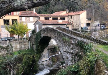
Tour Wandern von 12,7 km verfügbar auf Okzitanien, Ostpyrenäen, Glorianes. Diese Tour wird von MarcOBRECHT vorgeschlagen.
Beschreibung
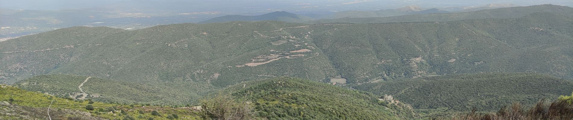
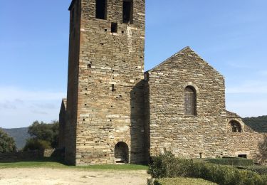
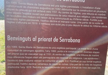
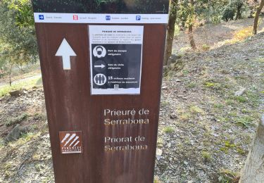
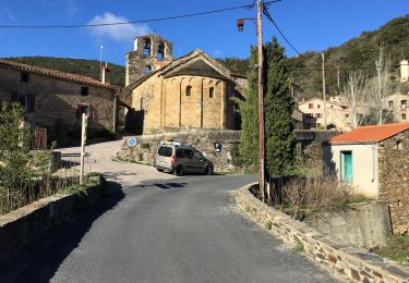
Depuis village vers col des Arques puis, à intersection, prendre sentier à droite vers chapelle Ste Anne. Retour le long de la clôture jusqu'à vue sur Serrabone.
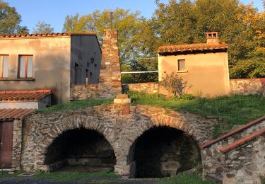
Revenir en arrière jusqu'à intersection et se diriger vers Gloriannes
Ort
Land:
France
Region :
Okzitanien
Abteilung/Provinz :
Ostpyrenäen
Kommune :
Glorianes
Standort:
Unknown
Gehen Sie:(Dec)
Gehen Sie:(UTM)
463461 ; 4715323 (31T) N.
Kommentare
Touren in der Umgebung
![Tour Wandern Boule-d'Amont - 20240104 Tour depuis le prieuré de Serrabonne - Photo](https://media.geolcdn.com/t/375/260/ext.jpg?maxdim=2&url=https%3A%2F%2Fmedia.geolcdn.com%2Ff%2Fa082747f-89ab-4e46-8caf-fd728589230f.jpg)
![Wandern Wandern](https://static1.geolcdn.com/sitytour/trail-icons/101.png)
20240104 Tour depuis le prieuré de Serrabonne
Wandern
Medium
Boule-d'Amont,
Okzitanien,
Ostpyrenäen,
France
![](/images/other/stat-length.png)
15,2 km | 26 km-effort
4h 37min
![](https://static1.geolcdn.com/siteimages/upload/files/16400158638029165_repeat_loop_refresh_sync_direction_icon.png)
Ja
![Tour Wandern Baillestavy - 20221127 Baillestavy- Valmanya - - Prat Mitja - Photo](https://media.geolcdn.com/t/375/260/ext.jpg?maxdim=2&url=https%3A%2F%2Fmedia.geolcdn.com%2Ff%2F72e21f75-cd75-4254-89f0-c0a060a5d8d3.jpg)
![Wandern Wandern](https://static1.geolcdn.com/sitytour/trail-icons/101.png)
20221127 Baillestavy- Valmanya - - Prat Mitja
Wandern
Schwierig
Baillestavy,
Okzitanien,
Ostpyrenäen,
France
![](/images/other/stat-length.png)
16,8 km | 30 km-effort
5h 2min
![](https://static1.geolcdn.com/siteimages/upload/files/16400158638029165_repeat_loop_refresh_sync_direction_icon.png)
Ja
![Tour Wandern Baillestavy - 20220519 Ballestavy - Photo](https://media.geolcdn.com/t/375/260/ext.jpg?maxdim=2&url=https%3A%2F%2Fmedia.geolcdn.com%2Ff%2F4d0efe9c-9bcb-43a8-b0f2-554388676ee1.jpg)
![Wandern Wandern](https://static1.geolcdn.com/sitytour/trail-icons/101.png)
20220519 Ballestavy
Wandern
Medium
Baillestavy,
Okzitanien,
Ostpyrenäen,
France
![](/images/other/stat-length.png)
12,6 km | 21 km-effort
3h 28min
![](https://static1.geolcdn.com/siteimages/upload/files/16400158638029165_repeat_loop_refresh_sync_direction_icon.png)
Ja
![Tour Wandern Boule-d'Amont - Serrabone /le roc rouge(le rocher du dragon):itinéraire 2 - Photo](https://media.geolcdn.com/t/375/260/ext.jpg?maxdim=2&url=https%3A%2F%2Fmedia.geolcdn.com%2Ff%2F26b43676-9e75-4b0d-befc-d44645d8fbe1.jpg)
![Wandern Wandern](https://static1.geolcdn.com/sitytour/trail-icons/101.png)
Serrabone /le roc rouge(le rocher du dragon):itinéraire 2
Wandern
Medium
Boule-d'Amont,
Okzitanien,
Ostpyrenäen,
France
![](/images/other/stat-length.png)
10,1 km | 17,5 km-effort
3h 32min
![](https://static1.geolcdn.com/siteimages/upload/files/16400158638029165_repeat_loop_refresh_sync_direction_icon.png)
Ja
![Tour Wandern Boule-d'Amont - Serra une - Photo](https://media.geolcdn.com/t/375/260/ext.jpg?maxdim=2&url=https%3A%2F%2Fmedia.geolcdn.com%2Ff%2F40936afc-9b58-415d-9be4-e3356895329e.jpg)
![Wandern Wandern](https://static1.geolcdn.com/sitytour/trail-icons/101.png)
Serra une
Wandern
Medium
Boule-d'Amont,
Okzitanien,
Ostpyrenäen,
France
![](/images/other/stat-length.png)
10,4 km | 17,8 km-effort
3h 44min
![](https://static1.geolcdn.com/siteimages/upload/files/16400158638029165_repeat_loop_refresh_sync_direction_icon.png)
Ja
![Tour Wandern Boule-d'Amont - 20210321 Boule d’Amont - Serrabone - Photo](https://media.geolcdn.com/t/375/260/ext.jpg?maxdim=2&url=https%3A%2F%2Fmedia.geolcdn.com%2Ff%2F16b44598-e6b8-4fe8-87e4-5112a1cd140b.jpg)
![Wandern Wandern](https://static1.geolcdn.com/sitytour/trail-icons/101.png)
20210321 Boule d’Amont - Serrabone
Wandern
Medium
Boule-d'Amont,
Okzitanien,
Ostpyrenäen,
France
![](/images/other/stat-length.png)
13,4 km | 23 km-effort
3h 58min
![](https://static1.geolcdn.com/siteimages/upload/files/16400158638029165_repeat_loop_refresh_sync_direction_icon.png)
Ja
![Tour Wandern Boule-d'Amont - Serrabonne autour du prieuré - Photo](https://media.geolcdn.com/t/375/260/ext.jpg?maxdim=2&url=https%3A%2F%2Fmedia.geolcdn.com%2Ff%2F24231eed-2f48-4061-8c52-7dd0f6f55a72.jpg)
![Wandern Wandern](https://static1.geolcdn.com/sitytour/trail-icons/101.png)
Serrabonne autour du prieuré
Wandern
Medium
Boule-d'Amont,
Okzitanien,
Ostpyrenäen,
France
![](/images/other/stat-length.png)
9,3 km | 16,2 km-effort
4h 27min
![](https://static1.geolcdn.com/siteimages/upload/files/16400158638029165_repeat_loop_refresh_sync_direction_icon.png)
Ja
![Tour Wandern Prunet-et-Belpuig - Boule d’amont Prunet-et-Belpuig la Trinité - Photo](https://media.geolcdn.com/t/375/260/ext.jpg?maxdim=2&url=https%3A%2F%2Fmedia.geolcdn.com%2Ff%2Fa989c071-b899-4092-a76b-68c708add189.jpg)
![Wandern Wandern](https://static1.geolcdn.com/sitytour/trail-icons/101.png)
Boule d’amont Prunet-et-Belpuig la Trinité
Wandern
Schwierig
Prunet-et-Belpuig,
Okzitanien,
Ostpyrenäen,
France
![](/images/other/stat-length.png)
13,7 km | 19,4 km-effort
3h 25min
![](https://static1.geolcdn.com/siteimages/upload/files/16400158638029165_repeat_loop_refresh_sync_direction_icon.png)
Ja
![Tour Wandern La Bastide - La Bastide-Palomere-StMarsal - Photo](https://media.geolcdn.com/t/375/260/ext.jpg?maxdim=2&url=https%3A%2F%2Fmedia.geolcdn.com%2Ff%2F066ff25d-18cd-428d-a0f2-6b6204b49f6e.jpg)
![Wandern Wandern](https://static1.geolcdn.com/sitytour/trail-icons/101.png)
La Bastide-Palomere-StMarsal
Wandern
Sehr schwierig
La Bastide,
Okzitanien,
Ostpyrenäen,
France
![](/images/other/stat-length.png)
19,8 km | 31 km-effort
6h 51min
![](https://static1.geolcdn.com/siteimages/upload/files/16400158638029165_repeat_loop_refresh_sync_direction_icon.png)
Ja