Tour Fahrrad Cavaillon - Autour du Luberon à vélo - Photo

Randonnées de Vélo Loisir Provence GUIDE+

© OpenStreetMap contributors
Länge
Länge
236 km
Maximale Höhe
Maximale Höhe
784 m
Positive Höhendifferenz
3738 m
Km-Effort
Km-Effort  
285 km
Min. Höhe
Min. Höhe
72 m
Negative Höhendifferenz
3738 m
Boucle
Boucle
Ja
Kennzeichnung
Kennzeichnung
Erstellungsdatum :
2015-11-02 00:00:00.0
Letzte Änderung :
2020-02-12 13:56:32.84

(4 Nachricht)

Fahrrad
Fahrrad
15h46
Schwierigkeit : Schwierig

Scannen Sie diesen QR-Code, um die Tour in der SityTrail-Anwendung zu öffnen

Kostenlosegpshiking-Anwendung

Logo SityTrail SityTrail

IGN / Geografische Institute

SityTrail aus dem App Store herunterladen SityTrail von Google Play herunterladen

Logo SityTrail SityTrail World

Die Welt öffnet sich für Sie

SityTrail aus dem App Store herunterladen SityTrail von Google Play herunterladen SityTrail auf Huawei AppGallery herunterladen

Über SityTrail

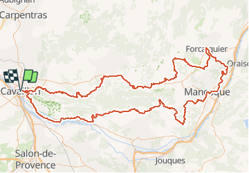
Tour Fahrrad von 236 km verfügbar auf Provence-Alpes-Côte d'Azur, Vaucluse, Cavaillon. Diese Tour wird von Vélo Loisir Provence vorgeschlagen.

Beschreibung

Around the Luberon by bike : A Different Adventure Every day ! Be tempted by this enchanting cycling itinerary tour around the Luberon massif, signposted in both directions. It opens up the possibility of gently exploring the wealth of resources of this exceptional territory. This circuit takes you through numerous high perched villages, to visit “bories” (ancient dwellings or tombs), chateaux (castles and stately homes) and monuments, but also come upon more humble buildings such as wash houses, water sources, chapels… High rocky outcrops and low scrub lands, grassy creeks, ravines and cedar forests, ochre cliffs…so much variety, such difference in scenery and wide diversity of vegetation all grouped together in an area of 60 by 30km/38 by 19 miles. This circular tour along lanes and bi- roads was chosen for the beauty of the sights and villages which welcome you at every stop. However, even though the routes are generally quiet, you share them with motorized vehicles and should remain vigilant at all times. The hilly landscape which characterises this countryside doesn’t always provide the gentlest of gradients for cyclists but the steep slopes are generally short and one can take advantage of the opportunity to walk a little ! A tour of the Luberon full of Flavour ! Witness to a lifestyle which is typically combined into its craftwork and local produce of the area, the wine (AOC Côtes du Luberon and Côtes du Ventoux, also Coteaux de Pierrevert) along with the gastronomy (preserved fruits, the “fruits confit d’Apt, goats cheese, honey, olive oil, fresh fruit and vegetables…) the local, weekly markets are the places to find these product and to revel in this colourful lifestyle.

Höhenprofil

Foto-Galerie

POIs

POI Cavaillon - Autour du Luberon à vélo - Photo
Vélo Loisir Provence
POI Cavaillon - Autour du Luberon à vélo - Photo
Vélo Loisir Provence

Ort

Land:
France
Region :
Provence-Alpes-Côte d'Azur
Abteilung/Provinz :
Vaucluse
Kommune :
Cavaillon
Standort:
Unknown
Gehen Sie:(Dec)
Gehen Sie:(UTM)
664270 ; 4855532 (31T) N.

Kommentare

Bitte melden Sie sich an, um einen Kommentar oder eine Bewertung zu hinterlassen


bel itinéraire


Touren in der Umgebung

Tour Fahrrad Cavaillon - Parcours n°3 - Cavaillon - Photo
Fahrrad
GUIDE+

Fahrrad

Einfach
(2)
Cavaillon, Provence-Alpes-Côte d'Azur, Vaucluse, France
45 km | 50 km-effort
2h 55min
Nein
Tour Fahrrad Cavaillon - Parcours n°1 - Cavaillon - Photo
Fahrrad
GUIDE+

Fahrrad

Schwierig
(2)
Cavaillon, Provence-Alpes-Côte d'Azur, Vaucluse, France
33 km | 41 km-effort
2h 21min
Ja
Tour Wandern Orgon - plan Orgon di19mai2013 - Photo
Wandern
tvtv84

Wandern

Einfach
(2)
Orgon, Provence-Alpes-Côte d'Azur, Bouches-du-Rhône, France
16 km | 18,8 km-effort
4h 28min
Ja
Tour Wandern Taillades - Par la Gorge de Badarel et les Rochers de Baude - Photo
Wandern
tracegps

Wandern

Medium
(3)
Taillades, Provence-Alpes-Côte d'Azur, Vaucluse, France
8 km | 14,7 km-effort
4h 0min
Ja
Tour Wandern Taillades - taillades - Photo
Wandern
fireman84

Wandern

Sehr leicht
(1)
Taillades, Provence-Alpes-Côte d'Azur, Vaucluse, France
7,6 km | 9,8 km-effort
1h 36min
Ja
Tour Wandern Taillades - Les Taillades-De la source du Boulon au Castelas - Gorge de Badarel sous la neige - Photo
Wandern
tracegps

Wandern

Schwierig
(1)
Taillades, Provence-Alpes-Côte d'Azur, Vaucluse, France
7 km | 10,8 km-effort
3h 0min
Ja
Tour Wandern Taillades - Taillades Badarel  Brayette Robion - Photo
Wandern
kephas

Wandern

Schwierig
(1)
Taillades, Provence-Alpes-Côte d'Azur, Vaucluse, France
10,6 km | 17,6 km-effort
3h 41min
Ja
Tour Wandern Cheval-Blanc - bergerie/badarel - Photo
Wandern
fireman84

Wandern

Medium
(1)
Cheval-Blanc, Provence-Alpes-Côte d'Azur, Vaucluse, France
9,9 km | 16 km-effort
3h 20min
Ja
Tour Mountainbike Cheval-Blanc - vidok vtt - Photo
Mountainbike
fireman84

Mountainbike

Schwierig
(2)
Cheval-Blanc, Provence-Alpes-Côte d'Azur, Vaucluse, France
17,4 km | 24 km-effort
1h 36min
Ja


Schließen
Meine Abonnements