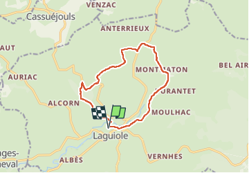
75 km | 90 km-effort
Laguiole Roc Del Cabres
antignacs
Benutzer GUIDE
Länge
12,3 km
Maximale Höhe
1135 m
Positive Höhendifferenz
299 m
Km-Effort
16,3 km
Min. Höhe
940 m
Negative Höhendifferenz
299 m
Boucle
Ja
Erstellungsdatum :
2024-02-07 07:40:56.0
Letzte Änderung :
2024-02-07 10:55:45.814
3h03
Schwierigkeit : Einfach
Kostenlosegpshiking-Anwendung
Über SityTrail
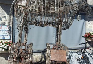
Tour Wandern von 12,3 km verfügbar auf Okzitanien, Aveyron, Laguiole. Diese Tour wird von antignacs vorgeschlagen.
Ort
Land:
France
Region :
Okzitanien
Abteilung/Provinz :
Aveyron
Kommune :
Laguiole
Standort:
Unknown
Gehen Sie:(Dec)
Gehen Sie:(UTM)
487794 ; 4948157 (31T) N.
Kommentare
Touren in der Umgebung
Les courbes infinies de l'Aubrac - Laguiole
Fahrrad
Schwierig
(1)
Laguiole,
Okzitanien,
Aveyron,
France
5h 0min
Ja
Cassuejouls 24 02 06
Wandern
Sehr leicht
Cassuéjouls,
Okzitanien,
Aveyron,
France
8,8 km | 12,1 km-effort
2h 17min
Ja
Laguiole Pigasse
Wandern
Einfach
Laguiole,
Okzitanien,
Aveyron,
France
6,2 km | 8,4 km-effort
1h 47min
Ja
le roc des cabres
Wandern
Einfach
Laguiole,
Okzitanien,
Aveyron,
France
13,7 km | 18,1 km-effort
4h 16min
Ja
la croix du Pal
Wandern
Medium
Curières,
Okzitanien,
Aveyron,
France
15,2 km | 22 km-effort
4h 29min
Ja
Laguiole PR-5
Zu Fuß
Einfach
Laguiole,
Okzitanien,
Aveyron,
France
6,3 km | 8,8 km-effort
1h 59min
Nein
Arioubadous
Wandern
Einfach
Laguiole,
Okzitanien,
Aveyron,
France
14,1 km | 18,1 km-effort
3h 17min
Ja
Boucle Laguiole Aveyron
Wandern
Schwierig
Laguiole,
Okzitanien,
Aveyron,
France
23 km | 29 km-effort
6h 34min
Ja
De Laguiole à Saint-Urcize
Wandern
Schwierig
Laguiole,
Okzitanien,
Aveyron,
France
16,3 km | 21 km-effort
3h 52min
Nein