![](/images/other/stat-length.png)
![Tour Wandern Ancy - SityTrail - ANCY par les crêtes au Nord-Est des Monts du Lyonnais - Photo](https://media.geolcdn.com/t/1900/400/ext.pjpeg?maxdim=2&url=https%3A%2F%2Fstatic1.geolcdn.com%2Fsiteimages%2Fupload%2Ffiles%2F1553511878bg_sport_marche.png)
SityTrail - ANCY par les crêtes au Nord-Est des Monts du Lyonnais
Dan69
Benutzer
![Länge](/images/other/stat-length.png)
Länge
19,4 km
![Maximale Höhe](https://static1.geolcdn.com/siteimages/upload/files/1508320355ic_sort_altitude_max_24dp.png)
Maximale Höhe
771 m
![Positive Höhendifferenz](https://static1.geolcdn.com/siteimages/upload/files/1508320355ic_sort_den_pos_24dp.png)
Positive Höhendifferenz
722 m
![Km-Effort](/images/other/stat-length.png)
Km-Effort
29 km
![Min. Höhe](https://static1.geolcdn.com/siteimages/upload/files/1508320355ic_sort_altitude_min_24dp.png)
Min. Höhe
435 m
![Negative Höhendifferenz](https://static1.geolcdn.com/siteimages/upload/files/1508320355ic_sort_den_neg_24dp.png)
Negative Höhendifferenz
722 m
![Boucle](https://static1.geolcdn.com/siteimages/upload/files/16400158638029165_repeat_loop_refresh_sync_direction_icon.png)
Boucle
Ja
Erstellungsdatum :
2024-03-23 11:20:43.626
Letzte Änderung :
2024-04-10 16:44:42.833
![Wandern](https://static1.geolcdn.com/sitytour/trail-icons/101.png)
6h35
Schwierigkeit : Schwierig
![Scannen Sie diesen QR-Code, um die Tour in der SityTrail-Anwendung zu öffnen](https://capi.geolives.com/qq0zvz2zws4bq2lad0pu/sitytour/trails/3990746/qr.png?size=200)
Kostenlosegpshiking-Anwendung
Über SityTrail
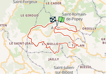
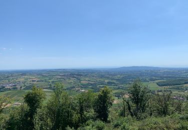
Tour Wandern von 19,4 km verfügbar auf Auvergne-Rhone-Alpen, Rhône, Ancy. Diese Tour wird von Dan69 vorgeschlagen.
Beschreibung
D/A : depuis le parking indiqué et situé à la sortie du village à gauche en venant de Savigny - Saint-Bel. Prendre à gauche la rue centrale, rejoindre le bourg et la mairie
Ort
Land:
France
Region :
Auvergne-Rhone-Alpen
Abteilung/Provinz :
Rhône
Kommune :
Ancy
Standort:
Unknown
Gehen Sie:(Dec)
Gehen Sie:(UTM)
617368 ; 5077270 (31T) N.
Kommentare
Touren in der Umgebung
![Tour Wandern Ancy - SityTrail - ANCY par les crêtes au Nord-Est des Monts du Lyonnais - Photo](https://media.geolcdn.com/t/375/260/ext.jpg?maxdim=2&url=https%3A%2F%2Fstatic1.geolcdn.com%2Fsiteimages%2Fupload%2Ffiles%2F1553511878bg_sport_marche.png)
![Wandern Wandern](https://static1.geolcdn.com/sitytour/trail-icons/101.png)
SityTrail - ANCY par les crêtes au Nord-Est des Monts du Lyonnais
Wandern
Medium
(1)
Ancy,
Auvergne-Rhone-Alpen,
Rhône,
France
![](/images/other/stat-length.png)
14 km | 20 km-effort
4h 39min
![](https://static1.geolcdn.com/siteimages/upload/files/16400158638029165_repeat_loop_refresh_sync_direction_icon.png)
Ja
![Tour Wandern Saint-Romain-de-Popey - Les cerisiers de Saint Romain de Popey - Photo](https://media.geolcdn.com/t/375/260/ext.jpg?maxdim=2&url=https%3A%2F%2Fmedia.geolcdn.com%2Ff%2F29b9bbfa-dc47-4a87-906f-96dd90692156.jpg)
![Wandern Wandern](https://static1.geolcdn.com/sitytour/trail-icons/101.png)
Les cerisiers de Saint Romain de Popey
Wandern
Einfach
Saint-Romain-de-Popey,
Auvergne-Rhone-Alpen,
Rhône,
France
![](/images/other/stat-length.png)
4,9 km | 7,8 km-effort
3h 10min
![](https://static1.geolcdn.com/siteimages/upload/files/16400158638029165_repeat_loop_refresh_sync_direction_icon.png)
Ja
![Tour Wandern Bibost - Bibost (69) 18,6 km-D. 719 m - Photo](https://media.geolcdn.com/t/375/260/ext.jpg?maxdim=2&url=https%3A%2F%2Fservices.sitytrail.com%2FGeolivesWS%2FDownloadMedia.ashx%3FTrailID%3D949831%26Media%3D20180423135012.jpg)
![Wandern Wandern](https://static1.geolcdn.com/sitytour/trail-icons/101.png)
Bibost (69) 18,6 km-D. 719 m
Wandern
Schwierig
Bibost,
Auvergne-Rhone-Alpen,
Rhône,
France
![](/images/other/stat-length.png)
18,6 km | 28 km-effort
5h 51min
![](https://static1.geolcdn.com/siteimages/upload/files/16400158638029165_repeat_loop_refresh_sync_direction_icon.png)
Ja
![Tour Elektrofahrrad Saint-Romain-de-Popey - matagrin du 19 mars - Photo](https://media.geolcdn.com/t/375/260/ext.jpg?maxdim=2&url=https%3A%2F%2Fservices.sitytrail.com%2FGeolivesWS%2FDownloadMedia.ashx%3FTrailID%3D926851%26Media%3Dfix__20180319132131.jpg)
![Elektrofahrrad Elektrofahrrad](https://static1.geolcdn.com/sitytour/trail-icons/205.png)
matagrin du 19 mars
Elektrofahrrad
Einfach
Saint-Romain-de-Popey,
Auvergne-Rhone-Alpen,
Rhône,
France
![](/images/other/stat-length.png)
45 km | 64 km-effort
Unbekannt
![](https://static1.geolcdn.com/siteimages/upload/files/16400158638029165_repeat_loop_refresh_sync_direction_icon.png)
Nein
![Tour Wandern Saint-Forgeux - Randonnée de Saint Forgeux à Ronzière - Photo](https://media.geolcdn.com/t/375/260/ext.jpg?maxdim=2&url=https%3A%2F%2Fservices.sitytrail.com%2FGeolivesWS%2FDownloadMedia.ashx%3FTrailID%3D109913%26Media%3D4928_2.jpg)
![Wandern Wandern](https://static1.geolcdn.com/sitytour/trail-icons/101.png)
Randonnée de Saint Forgeux à Ronzière
Wandern
Schwierig
Saint-Forgeux,
Auvergne-Rhone-Alpen,
Rhône,
France
![](/images/other/stat-length.png)
11,2 km | 16,8 km-effort
3h 0min
![](https://static1.geolcdn.com/siteimages/upload/files/16400158638029165_repeat_loop_refresh_sync_direction_icon.png)
Ja
![Tour Wandern Savigny - Variante2_Savigny_140524 - Photo](https://media.geolcdn.com/t/375/260/ext.jpg?maxdim=2&url=https%3A%2F%2Fstatic1.geolcdn.com%2Fsiteimages%2Fupload%2Ffiles%2F1553511878bg_sport_marche.png)
![Wandern Wandern](https://static1.geolcdn.com/sitytour/trail-icons/101.png)
Variante2_Savigny_140524
Wandern
Sehr schwierig
Savigny,
Auvergne-Rhone-Alpen,
Rhône,
France
![](/images/other/stat-length.png)
14,6 km | 19,2 km-effort
4h 22min
![](https://static1.geolcdn.com/siteimages/upload/files/16400158638029165_repeat_loop_refresh_sync_direction_icon.png)
Ja
![Tour Wandern Saint-Forgeux - Saint Forgeux - Photo](https://media.geolcdn.com/t/375/260/ext.jpg?maxdim=2&url=https%3A%2F%2Fstatic1.geolcdn.com%2Fsiteimages%2Fupload%2Ffiles%2F1553511878bg_sport_marche.png)
![Wandern Wandern](https://static1.geolcdn.com/sitytour/trail-icons/101.png)
Saint Forgeux
Wandern
Medium
(1)
Saint-Forgeux,
Auvergne-Rhone-Alpen,
Rhône,
France
![](/images/other/stat-length.png)
11,8 km | 17,6 km-effort
3h 4min
![](https://static1.geolcdn.com/siteimages/upload/files/16400158638029165_repeat_loop_refresh_sync_direction_icon.png)
Ja
![Tour Wandern Ancy - Projet_Amicale_Ancy_12 - Photo](https://media.geolcdn.com/t/375/260/ext.jpg?maxdim=2&url=https%3A%2F%2Fstatic1.geolcdn.com%2Fsiteimages%2Fupload%2Ffiles%2F1553511878bg_sport_marche.png)
![Wandern Wandern](https://static1.geolcdn.com/sitytour/trail-icons/101.png)
Projet_Amicale_Ancy_12
Wandern
Schwierig
(1)
Ancy,
Auvergne-Rhone-Alpen,
Rhône,
France
![](/images/other/stat-length.png)
12,1 km | 17,4 km-effort
3h 57min
![](https://static1.geolcdn.com/siteimages/upload/files/16400158638029165_repeat_loop_refresh_sync_direction_icon.png)
Ja
![Tour Wandern Saint-Romain-de-Popey - Crêt de popey - Photo](https://media.geolcdn.com/t/375/260/ext.jpg?maxdim=2&url=https%3A%2F%2Fmedia.geolcdn.com%2Ff%2Fc5c9f190-3cb9-431f-9212-d8302e03a157.jpg)
![Wandern Wandern](https://static1.geolcdn.com/sitytour/trail-icons/101.png)
Crêt de popey
Wandern
Medium
Saint-Romain-de-Popey,
Auvergne-Rhone-Alpen,
Rhône,
France
![](/images/other/stat-length.png)
4,8 km | 7,7 km-effort
1h 20min
![](https://static1.geolcdn.com/siteimages/upload/files/16400158638029165_repeat_loop_refresh_sync_direction_icon.png)
Ja