


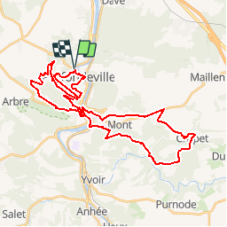
Profondeville VTT 38Kms

B0uille
Benutzer

Länge
38 km

Maximale Höhe
287 m

Positive Höhendifferenz
1064 m
Km-Effort
53 km

Min. Höhe
75 m

Negative Höhendifferenz
1064 m
Boucle
Ja
Erstellungsdatum :
2015-08-01 00:00:00.0
Letzte Änderung :
2015-08-01 00:00:00.0
3h18
Schwierigkeit : Schwierig

Kostenlosegpshiking-Anwendung
 SityTrail
IGN / Geografische Institute
SityTrail Plus
Die Welt öffnet sich für Sie
Über SityTrail
Tour Mountainbike von 38 km verfügbar auf Wallonien, Namur, Profondeville. Diese Tour wird von B0uille vorgeschlagen.
Ort
Land:
Belgium
Region :
Wallonien
Abteilung/Provinz :
Namur
Kommune :
Profondeville
Standort:
Profondeville
Gehen Sie:(Dec)
Gehen Sie:(UTM)
632739 ; 5582691 (31U) N.
Kommentare