


Binninea Loop Cullahill

mlmoroneybb
Benutzer


--
Schwierigkeit : Medium

Kostenlosegpshiking-Anwendung
 SityTrail
IGN / Geografische Institute
SityTrail Plus
Die Welt öffnet sich für Sie
Über SityTrail
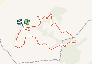
Tour Wandern von 10,2 km verfügbar auf Unbekannt, County Laois, The Municipal District of Borris-in-Ossory — Mountmellick. Diese Tour wird von mlmoroneybb vorgeschlagen.
Beschreibung
Starting from the mapboard at the car park 2Km from village, follow the purple arrow downhill for 200m to reach a pathway on your right. Follow this pathway uphill for 500m to reach a stile and exit the woodland.
Ort
Kommentare