Toudon, Maritime Alps: Best trails, routes and walks

3 comments

Toudon: Discover the best trails: 14 hiking trails and 2 bike and mountain-bike routes. All these trails, routes and outdoor activities are available in our SityTrail applications for smartphones and tablets.


The best trails (17)

Trail On foot Toudon - Cime des Collettes - Photo
On foot 7.037
Km
PRO

On foot

Easy
Toudon, Provence-Alpes-Côte d'Azur, Maritime Alps, France
7 km | 13.4 km-effort
3h 3min
477 m
487 m
Yes
SityTrail - itinéraires balisés pédestres

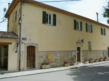
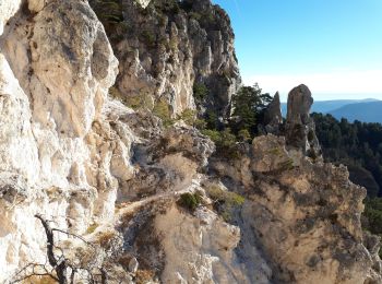
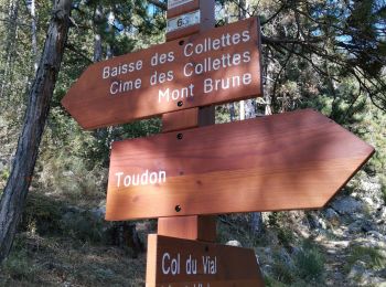
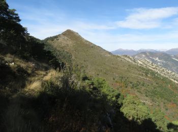
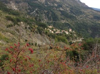
• Randonnée pédestre - Au départ de Toudon (970 m) Website: https://randoxygene.departement06.fr/esteron/cime-des-coll...

Trail Walking Toudon - cime des Colettes - Photo
Walking 7.72
Km

Walking

Medium
(1)
Toudon, Provence-Alpes-Côte d'Azur, Maritime Alps, France
7.7 km | 14.6 km-effort
3h 40min
538 m
463 m
No
franquen

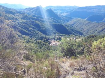
• départ du lavoir de Toudon pour une boucle de 3h30 environ, le plus souvent côté sud avec un panorama splendide sur l...

Trail Walking Toudon - Baisse des Colettes et Mt Brune de Toudon - Photo
Walking 13.316
Km

Walking

Medium
(1)
Toudon, Provence-Alpes-Côte d'Azur, Maritime Alps, France
13.3 km | 24 km-effort
4h 39min
815 m
816 m
Yes
GrouGary

Trail Walking Toudon - FFR - la Cime des Colettes  - Photo
Walking 7.849
Km

Walking

Medium
(1)
Toudon, Provence-Alpes-Côte d'Azur, Maritime Alps, France
7.8 km | 14.9 km-effort
4h 50min
530 m
533 m
Yes
clarambre

Trail Walking Toudon - Mont Brune depuis Toudon - Photo
Walking 14.672
Km

Walking

Medium
Toudon, Provence-Alpes-Côte d'Azur, Maritime Alps, France
14.7 km | 28 km-effort
5h 53min
972 m
968 m
Yes
aris

Trail Walking Toudon - Cime des Colettes par col de Vial - Photo
Walking 9.469
Km

Walking

Medium
Toudon, Provence-Alpes-Côte d'Azur, Maritime Alps, France
9.5 km | 18.4 km-effort
4h 11min
673 m
675 m
Yes
GrouGary

Trail Walking Toudon - Toudon mont Vial - Photo
Walking 15.247
Km

Walking

Difficult
Toudon, Provence-Alpes-Côte d'Azur, Maritime Alps, France
15.2 km | 28 km-effort
5h 19min
923 m
925 m
Yes
legios84

Trail Walking Toudon - VALESCREUS -TOUDON AR - Photo
Walking 11.624
Km

Walking

Difficult
Toudon, Provence-Alpes-Côte d'Azur, Maritime Alps, France
11.6 km | 23 km-effort
6h 38min
843 m
846 m
Yes
Benteux

Trail Walking Toudon - toudon - Photo
Walking 8.112
Km

Walking

Easy
Toudon, Provence-Alpes-Côte d'Azur, Maritime Alps, France
8.1 km | 14.6 km-effort
3h 2min
490 m
489 m
Yes
pierro06

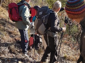
• Petite rando sympa!!!!

Trail Walking Toudon - Rando BV Toudon - Photo
Walking 12.85
Km

Walking

Very difficult
Toudon, Provence-Alpes-Côte d'Azur, Maritime Alps, France
12.8 km | 24 km-effort
4h 3min
825 m
823 m
Yes
GSananes

Trail Walking Toudon - La Meute TOUDON COLLETTES - Photo
Walking 7.468
Km

Walking

Medium
Toudon, Provence-Alpes-Côte d'Azur, Maritime Alps, France
7.5 km | 14.8 km-effort
3h 3min
547 m
548 m
Yes
DIDIERLESERT

Trail Mountain bike Toudon - vial malo 13 04 14 - Photo
Mountain bike 8.323
Km

Mountain bike

Medium
Toudon, Provence-Alpes-Côte d'Azur, Maritime Alps, France
8.3 km | 12.5 km-effort
1h 41min
7 m
1226 m
No
sylvainstaels

• single au top

Trail Mountain bike Toudon - Vescous - Photo
Mountain bike 20.995
Km

Mountain bike

Difficult
Toudon, Provence-Alpes-Côte d'Azur, Maritime Alps, France
21 km | 37 km-effort
2h 33min
1188 m
1186 m
Yes
fabiob

Trail Walking Toudon - toudon - Photo
Walking 14.838
Km

Walking

Difficult
Toudon, Provence-Alpes-Côte d'Azur, Maritime Alps, France
14.8 km | 24 km-effort
7h 13min
710 m
715 m
Yes
montagne06

Trail On foot Toudon - holly - Photo
On foot 7.281
Km

On foot

Very easy
Toudon, Provence-Alpes-Côte d'Azur, Maritime Alps, France
7.3 km | 13.6 km-effort
Unknown
479 m
446 m
Yes
brunotrail06

Trail Walking Toudon - Circuit des Pourraciers - Photo
Walking 10.266
Km

Walking

Easy
Toudon, Provence-Alpes-Côte d'Azur, Maritime Alps, France
10.3 km | 18 km-effort
4h 4min
582 m
572 m
Yes
xelot

Trail Other activity Toudon - Mont Brune - Photo
Other activity 10.794
Km

Other activity

Very easy
Toudon, Provence-Alpes-Côte d'Azur, Maritime Alps, France
10.8 km | 21 km-effort
5h 0min
787 m
792 m
Yes
jhw

17 trails displayed on 17

FREE GPS app for hiking

Logo SityTrail SityTrail

IGN / Geographical institutes

Download SityTrail from the App Store Download SityTrail from Google Play

Logo SityTrail SityTrail World

The world is yours!

Download SityTrail from the App Store Download SityTrail from Google Play Download SityTrail on Huawei AppGallery

Activities

Close
My subscriptions