Malcesine, Verona: Best trails, routes and walks

Malcesine: Discover the best trails: 13 hiking trails. All these trails, routes and outdoor activities are available in our SityTrail applications for smartphones and tablets.
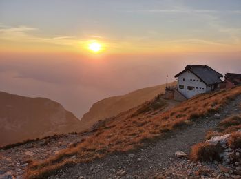

The best trails (13)

Trail On foot Malcesine - Sentiero delle Creste - Photo
On foot 11.523
Km
PRO

On foot

Medium
Malcesine, Veneto, Verona, Italy
11.5 km | 23 km-effort
5h 16min
1056 m
335 m
No
SityTrail - itinéraires balisés pédestres

• Trail created by Club Alpino Italiano Sezione Cesare Battisti di Verona. relation mantained by Club Alpino Italiano ...

Trail On foot Malcesine - Sentiero dei Contrabbandieri - Photo
On foot 3.334
Km
PRO

On foot

Easy
Malcesine, Veneto, Verona, Italy
3.3 km | 5.3 km-effort
1h 12min
38 m
488 m
No
SityTrail - itinéraires balisés pédestres

• Trail created by Club Alpino Italiano Sezione Cesare Battisti di Verona. relation mantained by Club Alpino Italiano ...

Trail On foot Malcesine - Cassone - San Maggiore innesto panoramica Malcesine - Photo
On foot 8.272
Km
PRO

On foot

Easy
Malcesine, Veneto, Verona, Italy
8.3 km | 18.4 km-effort
4h 11min
812 m
615 m
No
SityTrail - itinéraires balisés pédestres

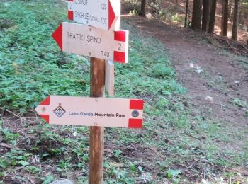
• Trail created by Club Alpino Italiano Sezione Cesare Battisti di Verona. Symbol: 1 on white red flag

Trail On foot Malcesine - Cassone - Pai di Sopra - Photo
On foot 12.122
Km
PRO

On foot

Medium
Malcesine, Veneto, Verona, Italy
12.1 km | 21 km-effort
4h 47min
679 m
644 m
No
SityTrail - itinéraires balisés pédestres

• Trail created by Club Alpino Italiano Sezione Cesare Battisti di Verona. relation mantained by Club Alpino Italiano ...

Trail On foot Malcesine - Navene - Bocca di Navene inn. sent. 651 - Photo
On foot 4.468
Km
PRO

On foot

Easy
Malcesine, Veneto, Verona, Italy
4.5 km | 8.2 km-effort
1h 51min
0 m
1115 m
No
SityTrail - itinéraires balisés pédestres

• Trail created by Club Alpino Italiano GASV Sottosezione della Sezione di Verona. Symbol: 634 on white red flag

Trail On foot Malcesine - Malcesine - Navene - Photo
On foot 6.398
Km
PRO

On foot

Easy
Malcesine, Veneto, Verona, Italy
6.4 km | 10.8 km-effort
2h 27min
330 m
333 m
No
SityTrail - itinéraires balisés pédestres

• Trail created by Club Alpino Italiano Sezione Cesare Battisti di Verona. Symbol: 4 on white red flag

Trail On foot Malcesine - San Michele - Tratto Spino - Photo
On foot 6.478
Km
PRO

On foot

Easy
Malcesine, Veneto, Verona, Italy
6.5 km | 10.1 km-effort
2h 18min
0 m
1098 m
No
SityTrail - itinéraires balisés pédestres

• Trail created by Club Alpino Italiano Sezione Cesare Battisti di Verona. Symbol: 2 on white red flag

Trail On foot Malcesine - Faigolo - Prai di Malcesine - Photo
On foot 3.744
Km
PRO

On foot

Easy
Malcesine, Veneto, Verona, Italy
3.7 km | 11.5 km-effort
2h 36min
773 m
1 m
No
SityTrail - itinéraires balisés pédestres

• Trail created by Club Alpino Italiano Sezione Cesare Battisti di Verona. Symbol: 10 on white red flag

Trail On foot Malcesine - Il Signor- Prai - Bocca di Navene - Photo
On foot 4.976
Km
PRO

On foot

Easy
Malcesine, Veneto, Verona, Italy
5 km | 11.1 km-effort
2h 31min
605 m
31 m
No
SityTrail - itinéraires balisés pédestres

• Trail created by Club Alpino Italiano Sezione Cesare Battisti di Verona. relation mantained by Club Alpino Italiano ...

Trail On foot Malcesine - Co di Piombi - Forcella Valdritta - Photo
On foot 5.345
Km
PRO

On foot

Easy
Malcesine, Veneto, Verona, Italy
5.3 km | 15.1 km-effort
3h 25min
960 m
38 m
No
SityTrail - itinéraires balisés pédestres

• Trail created by Club Alpino Italiano Sezione Cesare Battisti di Verona. Symbol: 5 on white red flag

Trail Walking Malcesine - Quercetto Piombi - Photo
Walking 12.225
Km

Walking

Difficult
Malcesine, Veneto, Verona, Italy
12.2 km | 25 km-effort
5h 20min
951 m
950 m
Yes
Morelli

Trail Walking Malcesine - Quercetto St Michele - Photo
Walking 5.168
Km

Walking

Easy
Malcesine, Veneto, Verona, Italy
5.2 km | 8.8 km-effort
2h 6min
268 m
274 m
Yes
Morelli

Trail Walking Malcesine - Malcesine St Michel - Photo
Walking 7.72
Km

Walking

Medium
Malcesine, Veneto, Verona, Italy
7.7 km | 14.3 km-effort
2h 30min
495 m
499 m
No
Morelli

13 trails displayed on 13

FREE GPS app for hiking

Logo SityTrail SityTrail

IGN / Geographical institutes

Download SityTrail from the App Store Download SityTrail from Google Play

Logo SityTrail SityTrail World

The world is yours!

Download SityTrail from the App Store Download SityTrail from Google Play Download SityTrail on Huawei AppGallery

Activities

Close
My subscriptions