


Wtnenne 7'7'2018

fra_depoorter
User
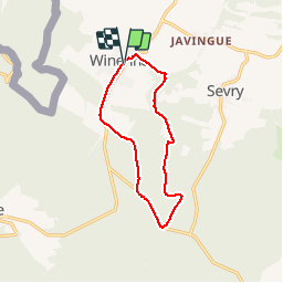

Length
10.1 km

Max alt
368 m

Uphill gradient
201 m
Km-Effort
12.8 km

Min alt
245 m

Downhill gradient
204 m
Boucle
Yes
Creation date :
2019-01-15 12:41:42.592
Updated on :
2019-01-15 12:41:42.592
2h04
Difficulty : Unknown

FREE GPS app for hiking
 SityTrail
IGN / Geographical institutes
SityTrail Plus
The world is yours!
About
Trail Walking of 10.1 km to be discovered at Wallonia, Namur, Beauraing. This trail is proposed by fra_depoorter.
Positioning
Country:
Belgium
Region :
Wallonia
Department/Province :
Namur
Municipality :
Beauraing
Location:
Winenne
Start:(Dec)
Start:(UTM)
635499 ; 5551138 (31U) N.
Comments