


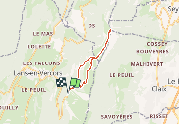
Lans en vercors-Le Moucherotte-Vercors

ThierryJ01
User

Length
10.4 km

Max alt
1882 m

Uphill gradient
504 m
Km-Effort
17.1 km

Min alt
1374 m

Downhill gradient
505 m
Boucle
Yes
Creation date :
2019-01-15 12:48:10.796
Updated on :
2020-10-18 15:43:50.845
3h30
Difficulty : Medium

FREE GPS app for hiking
 SityTrail
IGN / Geographical institutes
SityTrail Plus
The world is yours!
About
Trail Walking of 10.4 km to be discovered at Auvergne-Rhône-Alpes, Isère, Lans-en-Vercors. This trail is proposed by ThierryJ01.
Positioning
Country:
France
Region :
Auvergne-Rhône-Alpes
Department/Province :
Isère
Municipality :
Lans-en-Vercors
Location:
Unknown
Start:(Dec)
Start:(UTM)
705302 ; 4999332 (31T) N.
Comments