


Tour de Parmain par L Isle Adam

avdem
User
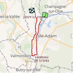

Length
7.6 km

Max alt
71 m

Uphill gradient
87 m
Km-Effort
8.7 km

Min alt
23 m

Downhill gradient
69 m
Boucle
No
Creation date :
2019-01-15 12:48:38.981
Updated on :
2019-01-15 12:48:38.981
1h48
Difficulty : Unknown

FREE GPS app for hiking
 SityTrail
IGN / Geographical institutes
SityTrail Plus
The world is yours!
About
Trail Other activity of 7.6 km to be discovered at Ile-de-France, Val-d'Oise, Parmain. This trail is proposed by avdem.
Description
facile 2 h
Positioning
Country:
France
Region :
Ile-de-France
Department/Province :
Val-d'Oise
Municipality :
Parmain
Location:
Unknown
Start:(Dec)
Start:(UTM)
442631 ; 5441515 (31U) N.
Comments