


fretes

DPICHOT
User
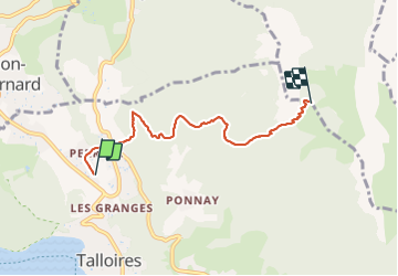

Length
4.9 km

Max alt
1637 m

Uphill gradient
1089 m
Km-Effort
15.8 km

Min alt
549 m

Downhill gradient
6 m
Boucle
No
Creation date :
2018-07-11 07:53:52.525
Updated on :
2018-07-11 07:53:52.525
1h42
Difficulty : Unknown

FREE GPS app for hiking
 SityTrail
IGN / Geographical institutes
SityTrail Plus
The world is yours!
About
Trail Other activity of 4.9 km to be discovered at Auvergne-Rhône-Alpes, Upper Savoy, Talloires-Montmin. This trail is proposed by DPICHOT.
Description
paraoente
Positioning
Country:
France
Region :
Auvergne-Rhône-Alpes
Department/Province :
Upper Savoy
Municipality :
Talloires-Montmin
Location:
Talloires
Start:(Dec)
Start:(UTM)
283609 ; 5081014 (32T) N.
Comments