


Chamonix... La Floria...

r.genette
User
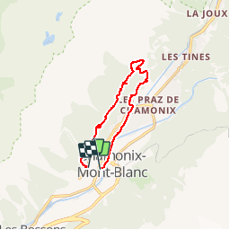

Length
9.9 km

Max alt
1445 m

Uphill gradient
518 m
Km-Effort
17 km

Min alt
1037 m

Downhill gradient
564 m
Boucle
No
Creation date :
2019-01-15 12:51:58.865
Updated on :
2019-01-15 12:51:58.865
3h07
Difficulty : Medium

FREE GPS app for hiking
 SityTrail
IGN / Geographical institutes
SityTrail Plus
The world is yours!
About
Trail Walking of 9.9 km to be discovered at Auvergne-Rhône-Alpes, Upper Savoy, Chamonix-Mont-Blanc. This trail is proposed by r.genette.
Description
randonnée agréable...du dénivelé...mais correct...
Positioning
Country:
France
Region :
Auvergne-Rhône-Alpes
Department/Province :
Upper Savoy
Municipality :
Chamonix-Mont-Blanc
Location:
Unknown
Start:(Dec)
Start:(UTM)
334356 ; 5087778 (32T) N.
Comments