


La font du Griffe

jdelettrez
User
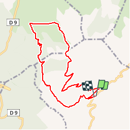

Length
10.1 km

Max alt
765 m

Uphill gradient
437 m
Km-Effort
15.9 km

Min alt
400 m

Downhill gradient
434 m
Boucle
Yes
Creation date :
2019-01-15 12:54:00.347
Updated on :
2019-04-27 10:07:49.524
3h17
Difficulty : Medium

FREE GPS app for hiking
 SityTrail
IGN / Geographical institutes
SityTrail Plus
The world is yours!
About
Trail Walking of 10.1 km to be discovered at Occitania, Hérault, Montpeyroux. This trail is proposed by jdelettrez.
Description
Randonnée sous le pic St Baudille
Positioning
Country:
France
Region :
Occitania
Department/Province :
Hérault
Municipality :
Montpeyroux
Location:
Unknown
Start:(Dec)
Start:(UTM)
539667 ; 4842567 (31T) N.
Comments