


Refuge du Pavé

libertju
User
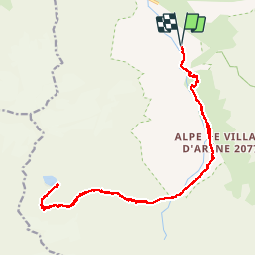

Length
24 km

Max alt
2912 m

Uphill gradient
1308 m
Km-Effort
42 km

Min alt
1707 m

Downhill gradient
1307 m
Boucle
Yes
Creation date :
2018-08-19 08:46:01.216
Updated on :
2018-08-19 08:46:01.216
8h30
Difficulty : Difficult

FREE GPS app for hiking
 SityTrail
IGN / Geographical institutes
SityTrail Plus
The world is yours!
About
Trail Walking of 24 km to be discovered at Provence-Alpes-Côte d'Azur, Hautes-Alpes, Villar-d'Arêne. This trail is proposed by libertju.
Positioning
Country:
France
Region :
Provence-Alpes-Côte d'Azur
Department/Province :
Hautes-Alpes
Municipality :
Villar-d'Arêne
Location:
Unknown
Start:(Dec)
Start:(UTM)
292853 ; 4988571 (32T) N.
Comments