


GTA J2

PhilippeC54
User
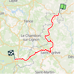

Length
44 km

Max alt
1208 m

Uphill gradient
914 m
Km-Effort
56 km

Min alt
998 m

Downhill gradient
856 m
Boucle
No
Creation date :
2019-01-15 13:10:11.847
Updated on :
2019-01-15 13:10:11.847
4h48
Difficulty : Medium

FREE GPS app for hiking
 SityTrail
IGN / Geographical institutes
SityTrail Plus
The world is yours!
About
Trail Mountain bike of 44 km to be discovered at Auvergne-Rhône-Alpes, Haute-Loire, Saint-Bonnet-le-Froid. This trail is proposed by PhilippeC54.
Positioning
Country:
France
Region :
Auvergne-Rhône-Alpes
Department/Province :
Haute-Loire
Municipality :
Saint-Bonnet-le-Froid
Location:
Unknown
Start:(Dec)
Start:(UTM)
612827 ; 4999732 (31T) N.
Comments