


GTA J3 partiel

PhilippeC54
User

Length
25 km

Max alt
1605 m

Uphill gradient
788 m
Km-Effort
35 km

Min alt
1123 m

Downhill gradient
610 m
Boucle
No
Creation date :
2019-01-15 13:10:14.272
Updated on :
2019-01-15 13:10:14.272
3h20
Difficulty : Unknown

FREE GPS app for hiking
 SityTrail
IGN / Geographical institutes
SityTrail Plus
The world is yours!
About
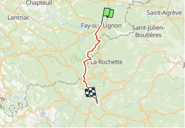
Trail Mountain bike of 25 km to be discovered at Auvergne-Rhône-Alpes, Haute-Loire, Fay-sur-Lignon. This trail is proposed by PhilippeC54.
Description
Abandon des 18 Km restants suite à orage de grêle au Mont Gerbier de Jonc
Positioning
Country:
France
Region :
Auvergne-Rhône-Alpes
Department/Province :
Haute-Loire
Municipality :
Fay-sur-Lignon
Location:
Unknown
Start:(Dec)
Start:(UTM)
596704 ; 4982270 (31T) N.
Comments