


GTA J4

PhilippeC54
User
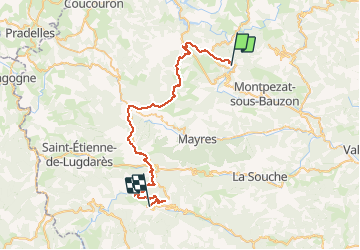

Length
47 km

Max alt
1444 m

Uphill gradient
1354 m
Km-Effort
65 km

Min alt
1049 m

Downhill gradient
1387 m
Boucle
No
Creation date :
2019-01-15 13:10:15.613
Updated on :
2019-01-15 13:10:15.613
6h56
Difficulty : Difficult

FREE GPS app for hiking
 SityTrail
IGN / Geographical institutes
SityTrail Plus
The world is yours!
About
Trail Mountain bike of 47 km to be discovered at Auvergne-Rhône-Alpes, Ardèche, Le Roux. This trail is proposed by PhilippeC54.
Positioning
Country:
France
Region :
Auvergne-Rhône-Alpes
Department/Province :
Ardèche
Municipality :
Le Roux
Location:
Unknown
Start:(Dec)
Start:(UTM)
591880 ; 4954495 (31T) N.
Comments