


chapelle Notre-Dame des anges

jbo1
User
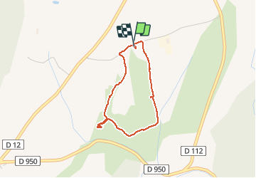

Length
2.9 km

Max alt
752 m

Uphill gradient
42 m
Km-Effort
3.5 km

Min alt
712 m

Downhill gradient
43 m
Boucle
Yes
Creation date :
2019-01-15 13:10:58.521
Updated on :
2019-01-15 13:10:58.521
1h10
Difficulty : Very easy

FREE GPS app for hiking
 SityTrail
IGN / Geographical institutes
SityTrail Plus
The world is yours!
About
Trail Walking of 2.9 km to be discovered at Provence-Alpes-Côte d'Azur, Alpes-de-Haute-Provence, Banon. This trail is proposed by jbo1.
Positioning
Country:
France
Region :
Provence-Alpes-Côte d'Azur
Department/Province :
Alpes-de-Haute-Provence
Municipality :
Banon
Location:
Unknown
Start:(Dec)
Start:(UTM)
712984 ; 4881458 (31T) N.
Comments