Trail Running Saiguède - Raide de Saiguède - Photo
 tracegps
tracegps

User

© OpenStreetMap contributors
Length
Length
19 km
Max alt
Max alt
322 m
Uphill gradient
Uphill gradient
279 m
Km-Effort
Km-Effort  
23 km
Min alt
Min alt
228 m
Downhill gradient
Downhill gradient
279 m
Boucle
Boucle
Yes
Creation date :
2014-12-10 00:00:00.0
Updated on :
2014-12-10 00:00:00.0

(0 Reviews)

Running
Running
2h00
Difficulty : Very difficult

Scan this QR Code to open this trail in the SityTrail application

FREE GPS app for hiking

Logo SityTrail SityTrail

IGN / Geographical institutes

Download SityTrail from the App Store Download SityTrail from Google Play

Logo SityTrail SityTrail Plus

The world is yours!

Download SityTrail from the App Store Download SityTrail from Google Play Download SityTrail on Huawei AppGallery

About

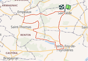
Trail Running of 19 km to be discovered at Occitania, Haute-Garonne, Saiguède. This trail is proposed by tracegps.

Description

Saiguède, en Saves, est située sur la ligne de crête de partage des eaux entre la Save et la Garonne, à 25 km à l'ouest de Toulouse. Dès le départ, on grimpe .... pendant 4 km sur 100 m de dénivelé. Après 7,5 km, à Larroudé, joli chemin de 1 km. Puis, à 14 km, on longe le Lac de Minjoulet, dans les faubourgs de Ste Foy de Peyrolières, avant de revenir en montée et en descente sur Saiguède.

Elevation profile

Photos

Positioning

Country:
France
Region :
Occitania
Department/Province :
Haute-Garonne
Municipality :
Saiguède
Location:
Unknown
Start:(UTM)
350086 ; 4821237 (31T) N.


Close
My subscriptions