


Voissière

jeanic63
User
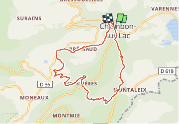

Length
9.7 km

Max alt
1126 m

Uphill gradient
422 m
Km-Effort
15.3 km

Min alt
886 m

Downhill gradient
424 m
Boucle
Yes
Creation date :
2019-01-15 13:17:27.964
Updated on :
2021-04-11 12:56:18.398
3h29
Difficulty : Easy

FREE GPS app for hiking
 SityTrail
IGN / Geographical institutes
SityTrail Plus
The world is yours!
About
Trail On foot of 9.7 km to be discovered at Auvergne-Rhône-Alpes, Puy-de-Dôme, Chambon-sur-Lac. This trail is proposed by jeanic63.
Description
départ Chambon sur lac


Positioning
Country:
France
Region :
Auvergne-Rhône-Alpes
Department/Province :
Puy-de-Dôme
Municipality :
Chambon-sur-Lac
Location:
Unknown
Start:(Dec)
Start:(UTM)
491963 ; 5046449 (31T) N.
Comments