Trail Mountain bike Andlau - Sentier Adélaïde - Photo

Sentier Adélaïde

 tracegps
tracegps

User

© OpenStreetMap contributors
Length
Length
22 km
Max alt
Max alt
772 m
Uphill gradient
Uphill gradient
773 m
Km-Effort
Km-Effort  
32 km
Min alt
Min alt
257 m
Downhill gradient
Downhill gradient
771 m
Boucle
Boucle
Yes
Creation date :
2014-12-10 00:00:00.0
Updated on :
2014-12-10 00:00:00.0

(1 Reviews)

Mountain bike
Mountain bike
2h00
Difficulty : Very difficult

Scan this QR Code to open this trail in the SityTrail application

FREE GPS app for hiking

Logo SityTrail SityTrail

IGN / Geographical institutes

Download SityTrail from the App Store Download SityTrail from Google Play

Logo SityTrail SityTrail World

The world is yours!

Download SityTrail from the App Store Download SityTrail from Google Play Download SityTrail on Huawei AppGallery

About

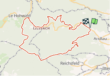
Trail Mountain bike of 22 km to be discovered at Grand Est, Bas-Rhin, Andlau. This trail is proposed by tracegps.

Description

Ce circuit est balisé entre Andlau et Le Hohwald en passant par la M.F. de Lilsbach. Le retour est une variante proposée sur les panneaux d'information que vous rencontrerez tout au long de ce parcours. La première partie vers Le Hohwald est une longue montée entrecoupée de petites descentes. Le chemin est large, excepté avant Sperberbaechel où il peut devenir franchement gras après une pluie.... La suite et une carte détaillée sont ICI

Elevation profile

Photos

Positioning

Country:
France
Region :
Grand Est
Department/Province :
Bas-Rhin
Municipality :
Andlau
Location:
Unknown
Start:(Dec)
Start:(UTM)
382050 ; 5361353 (32U) N.

Comments

Please log in to post a review or rate the element


Trails nearby

Trail Walking Ottrott - Le circuit sud du Mur Païen - Photo
Walking
VacheKiri67

Walking

Easy
(2)
Ottrott, Grand Est, Bas-Rhin, France
4.9 km | 6.3 km-effort
1h 56min
No
Trail Walking Ottrott - Le circuit nord du Mur Païen - Photo
Walking
VacheKiri67

Walking

Easy
(1)
Ottrott, Grand Est, Bas-Rhin, France
5.9 km | 8.5 km-effort
2h 4min
No
Trail Walking Andlau - Depuis Andlau vers le village viticole de Mittelbergheim - Photo
Walking
VacheKiri67

Walking

Medium
(1)
Andlau, Grand Est, Bas-Rhin, France
11.9 km | 15.9 km-effort
4h 3min
Yes
Trail Walking Ottrott - Le mur païen - Photo
Walking
VacheKiri67

Walking

Medium
(4)
Ottrott, Grand Est, Bas-Rhin, France
10.5 km | 14.5 km-effort
4h 36min
Yes
Trail Walking Ottrott - Mur Paien complet - Photo
Walking
markrei

Walking

Medium
(1)
Ottrott, Grand Est, Bas-Rhin, France
12 km | 16.4 km-effort
5h 25min
Yes
Trail Mountain bike Barr - Circuit des 3 Petits Ponts - Photo
Mountain bike
tracegps

Mountain bike

Difficult
(1)
Barr, Grand Est, Bas-Rhin, France
15.9 km | 22 km-effort
1h 19min
Yes
Trail Horseback riding Epfig - 2022-11-11 Journee Epfig Nothalten Dambach - Photo
Horseback riding
GUIDE
holtzv

Horseback riding

Medium
Epfig, Grand Est, Bas-Rhin, France
22 km | 27 km-effort
3h 48min
Yes
Trail Walking Reichsfeld - 2019-12-28 Marche Reichsfeld Ungersberg Gruckert - Photo
Walking
GUIDE
holtzv

Walking

Very easy
Reichsfeld, Grand Est, Bas-Rhin, France
12.2 km | 20 km-effort
3h 5min
Yes
Trail Walking Nothalten - nothalten - Photo
Walking
rensmusic

Walking

Very easy
(1)
Nothalten, Grand Est, Bas-Rhin, France
9.6 km | 13 km-effort
2h 13min
No


Close
My subscriptions