


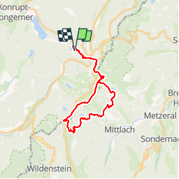
rando des 4 lacs

Sartor
User

Length
26 km

Max alt
1355 m

Uphill gradient
1566 m
Km-Effort
47 km

Min alt
780 m

Downhill gradient
1563 m
Boucle
Yes
Creation date :
2019-01-15 13:51:13.816
Updated on :
2019-01-15 13:51:13.816
5h47
Difficulty : Difficult

FREE GPS app for hiking
 SityTrail
IGN / Geographical institutes
SityTrail Plus
The world is yours!
About
Trail Walking of 26 km to be discovered at Grand Est, Vosges, Xonrupt-Longemer. This trail is proposed by Sartor.
Positioning
Country:
France
Region :
Grand Est
Department/Province :
Vosges
Municipality :
Xonrupt-Longemer
Location:
Unknown
Start:(Dec)
Start:(UTM)
350024 ; 5324437 (32U) N.
Comments