Trail Mountain bike Bischoffsheim - Entre Bischoffsheim et Ungersberg - Photo

Entre Bischoffsheim et Ungersberg

 tracegps
tracegps

User

© OpenStreetMap contributors
Length
Length
56 km
Max alt
Max alt
769 m
Uphill gradient
Uphill gradient
1465 m
Km-Effort
Km-Effort  
75 km
Min alt
Min alt
183 m
Downhill gradient
Downhill gradient
1465 m
Boucle
Boucle
Yes
Creation date :
2014-12-10 00:00:00.0
Updated on :
2014-12-10 00:00:00.0

(0 Reviews)

Mountain bike
Mountain bike
5h00
Difficulty : Very difficult

Scan this QR Code to open this trail in the SityTrail application

FREE GPS app for hiking

Logo SityTrail SityTrail

IGN / Geographical institutes

Download SityTrail from the App Store Download SityTrail from Google Play

Logo SityTrail SityTrail World

The world is yours!

Download SityTrail from the App Store Download SityTrail from Google Play Download SityTrail on Huawei AppGallery

About

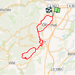
Trail Mountain bike of 56 km to be discovered at Grand Est, Bas-Rhin, Bischoffsheim. This trail is proposed by tracegps.

Description

D'autres infos sont ICI Source: Claude

Elevation profile

Photos

Positioning

Country:
France
Region :
Grand Est
Department/Province :
Bas-Rhin
Municipality :
Bischoffsheim
Location:
Unknown
Start:(UTM)
388990 ; 5371544 (32U) N.

Trails nearby

Trail Walking Dorlisheim - Escapade dans le vignoble de Dorlisheim - Photo
Walking
tracegps

Walking

Medium
(1)
Dorlisheim, Grand Est, Bas-Rhin, France
9.7 km | 12.6 km-effort
3h 0min
Yes
Trail Walking Obernai - Obernai gare - Mont St Odile - Photo
Walking
tracegps

Walking

Difficult
(2)
Obernai, Grand Est, Bas-Rhin, France
20 km | 29 km-effort
5h 0min
Yes
Trail Mountain bike Ottrott - Sainte-Odile East-Face - Photo
Mountain bike
tracegps

Mountain bike

Difficult
(1)
Ottrott, Grand Est, Bas-Rhin, France
24 km | 39 km-effort
3h 0min
Yes
Trail On foot Rosheim - Circuit du Vignoble - Photo
On foot
PRO

On foot

Easy
Rosheim, Grand Est, Bas-Rhin, France
8.8 km | 11.7 km-effort
2h 38min
Yes
Trail On foot Bischoffsheim - Circuit des Balcons - Photo
On foot
PRO

On foot

Easy
(1)
Bischoffsheim, Grand Est, Bas-Rhin, France
12.4 km | 15.4 km-effort
3h 30min
Yes
Trail Mountain bike Rosheim - schnacker tour le grand 8 circuit magique - Photo
Mountain bike
raphnou

Mountain bike

Difficult
(1)
Rosheim, Grand Est, Bas-Rhin, France
29 km | 39 km-effort
2h 30min
Yes
Trail Walking Rosenwiller - 2015-05-17 Marche Gourmande Rosenwiller - Photo
Walking
GUIDE
holtzv

Walking

Easy
(1)
Rosenwiller, Grand Est, Bas-Rhin, France
8.8 km | 11 km-effort
2h 23min
No
Trail Walking Rosheim - Les balcons de Rosheim (variante) - Photo
Walking
Mich&Agnès

Walking

Easy
Rosheim, Grand Est, Bas-Rhin, France
13.4 km | 16.8 km-effort
3h 48min
Yes
Trail Walking Obernai - Obernai - Boersch - Photo
Walking
Bart2015

Walking

Medium
Obernai, Grand Est, Bas-Rhin, France
12.7 km | 15.6 km-effort
2h 20min
Yes


Close
My subscriptions