


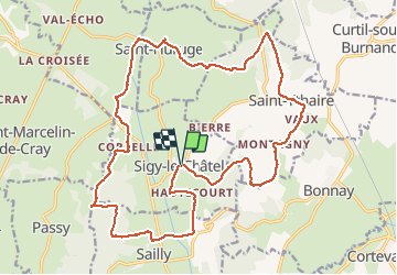
Sigy le chatel

yakout
User

Length
23 km

Max alt
397 m

Uphill gradient
543 m
Km-Effort
30 km

Min alt
211 m

Downhill gradient
541 m
Boucle
Yes
Creation date :
2019-01-15 14:00:57.53
Updated on :
2019-01-15 14:00:57.53
6h28
Difficulty : Unknown

FREE GPS app for hiking
 SityTrail
IGN / Geographical institutes
SityTrail Plus
The world is yours!
About
Trail Walking of 23 km to be discovered at Bourgogne-Franche-Comté, Saône-et-Loire, Sigy-le-Châtel. This trail is proposed by yakout.
Positioning
Country:
France
Region :
Bourgogne-Franche-Comté
Department/Province :
Saône-et-Loire
Municipality :
Sigy-le-Châtel
Location:
Unknown
Start:(Dec)
Start:(UTM)
620730 ; 5156861 (31T) N.
Comments