


St Genix - La Balme

leeho
User
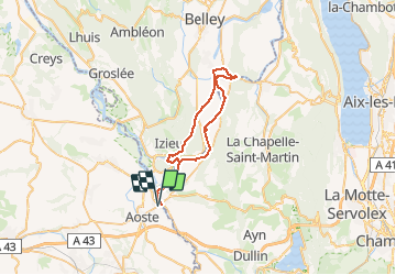

Length
42 km

Max alt
340 m

Uphill gradient
456 m
Km-Effort
48 km

Min alt
210 m

Downhill gradient
455 m
Boucle
Yes
Creation date :
2019-01-15 14:05:36.481
Updated on :
2019-01-15 14:05:36.481
2h49
Difficulty : Easy

FREE GPS app for hiking
 SityTrail
IGN / Geographical institutes
SityTrail Plus
The world is yours!
About
Trail Cycle of 42 km to be discovered at Auvergne-Rhône-Alpes, Isère, Aoste. This trail is proposed by leeho.
Description
Boucle en remontant le Rhône vers La Balme au départ de l'hôtel Bellet (le Coq en Velours)
Positioning
Country:
France
Region :
Auvergne-Rhône-Alpes
Department/Province :
Isère
Municipality :
Aoste
Location:
Unknown
Start:(Dec)
Start:(UTM)
705024 ; 5052627 (31T) N.
Comments