


gtj_ped_complet_bd

bruno38
User
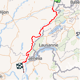

Length
385 km

Max alt
1710 m

Uphill gradient
13293 m
Km-Effort
562 km

Min alt
236 m

Downhill gradient
13392 m
Boucle
No
Creation date :
2019-01-15 14:06:44.668
Updated on :
2019-01-15 14:06:44.668
--
Difficulty : Unknown

FREE GPS app for hiking
 SityTrail
IGN / Geographical institutes
SityTrail Plus
The world is yours!
About
Trail Walking of 385 km to be discovered at Bourgogne-Franche-Comté, Doubs, Mandeure. This trail is proposed by bruno38.
Positioning
Country:
France
Region :
Bourgogne-Franche-Comté
Department/Province :
Doubs
Municipality :
Mandeure
Location:
Unknown
Start:(Dec)
Start:(UTM)
334296 ; 5257504 (32T) N.
Comments