


bien

stef789
User GUIDE
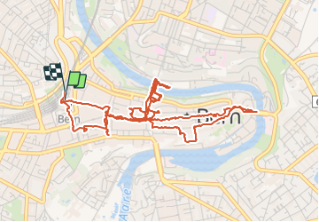

Length
6.9 km

Max alt
557 m

Uphill gradient
141 m
Km-Effort
8.8 km

Min alt
504 m

Downhill gradient
141 m
Boucle
Yes
Creation date :
2019-01-15 14:13:46.635
Updated on :
2019-01-15 14:13:46.635
3h50
Difficulty : Unknown

FREE GPS app for hiking
 SityTrail
IGN / Geographical institutes
SityTrail Plus
The world is yours!
About
Trail Walking of 6.9 km to be discovered at Bern, Bern-Mittelland administrative district, Bern. This trail is proposed by stef789.
Positioning
Country:
Switzerland
Region :
Bern
Department/Province :
Bern-Mittelland administrative district
Municipality :
Bern
Location:
Stadtteil I
Start:(Dec)
Start:(UTM)
381262 ; 5200711 (32T) N.
Comments