


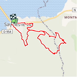
circuit de serre verger N°25

guariso
User

Length
9.8 km

Max alt
1215 m

Uphill gradient
455 m
Km-Effort
15.8 km

Min alt
794 m

Downhill gradient
442 m
Boucle
No
Creation date :
2018-09-22 21:35:55.799
Updated on :
2018-09-22 21:35:55.799
1h30
Difficulty : Medium

FREE GPS app for hiking
 SityTrail
IGN / Geographical institutes
SityTrail Plus
The world is yours!
About
Trail Mountain bike of 9.8 km to be discovered at Provence-Alpes-Côte d'Azur, Hautes-Alpes, Savines-le-Lac. This trail is proposed by guariso.
Description
montée sans difficulté technique, descente sportive quand même,surtout par sol humide.
Positioning
Country:
France
Region :
Provence-Alpes-Côte d'Azur
Department/Province :
Hautes-Alpes
Municipality :
Savines-le-Lac
Location:
Unknown
Start:(Dec)
Start:(UTM)
293419 ; 4933418 (32T) N.
Comments