


LES CALANQUES

maginot
User
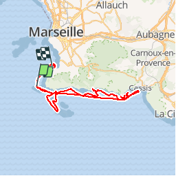

Length
59 km

Max alt
38 m

Uphill gradient
245 m
Km-Effort
62 km

Min alt
-6 m

Downhill gradient
234 m
Boucle
No
Creation date :
2019-01-16 09:43:43.88
Updated on :
2019-01-16 09:43:43.88
7h49
Difficulty : Very easy

FREE GPS app for hiking
 SityTrail
IGN / Geographical institutes
SityTrail Plus
The world is yours!
About
Trail Other activity of 59 km to be discovered at Provence-Alpes-Côte d'Azur, Bouches-du-Rhône, Marseille. This trail is proposed by maginot.
Description
Super Sortie en mer les calanques jusqu'à à Cassis .Magnfique
Positioning
Country:
France
Region :
Provence-Alpes-Côte d'Azur
Department/Province :
Bouches-du-Rhône
Municipality :
Marseille
Location:
8th Arrondissement
Start:(Dec)
Start:(UTM)
689446 ; 4787431 (31T) N.
Comments