


la croix de belledonne

gsouque
User
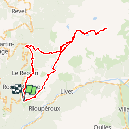

Length
36 km

Max alt
2897 m

Uphill gradient
2434 m
Km-Effort
68 km

Min alt
1126 m

Downhill gradient
2413 m
Boucle
Yes
Creation date :
2019-01-15 14:27:13.589
Updated on :
2019-01-15 14:27:13.589
10h00
Difficulty : Medium

FREE GPS app for hiking
 SityTrail
IGN / Geographical institutes
SityTrail Plus
The world is yours!
About
Trail Walking of 36 km to be discovered at Auvergne-Rhône-Alpes, Isère, Chamrousse. This trail is proposed by gsouque.
Positioning
Country:
France
Region :
Auvergne-Rhône-Alpes
Department/Province :
Isère
Municipality :
Chamrousse
Location:
Unknown
Start:(Dec)
Start:(UTM)
726350 ; 4998024 (31T) N.
Comments