


Planpraz, Col et Lac du Brévent - Refuge de Bellachat depuis Refuge de la Flégère

gregou74
User
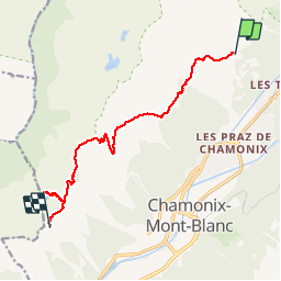

Length
11.1 km

Max alt
2487 m

Uphill gradient
907 m
Km-Effort
22 km

Min alt
1810 m

Downhill gradient
626 m
Boucle
No
Creation date :
2019-04-27 13:17:02.865
Updated on :
2019-04-27 13:17:02.917
4h34
Difficulty : Difficult

FREE GPS app for hiking
 SityTrail
IGN / Geographical institutes
SityTrail Plus
The world is yours!
About
Trail Walking of 11.1 km to be discovered at Auvergne-Rhône-Alpes, Upper Savoy, Chamonix-Mont-Blanc. This trail is proposed by gregou74.
Description
Tour des Aiguilles Rouges - Jour 2
Positioning
Country:
France
Region :
Auvergne-Rhône-Alpes
Department/Province :
Upper Savoy
Municipality :
Chamonix-Mont-Blanc
Location:
Unknown
Start:(Dec)
Start:(UTM)
336283 ; 5091766 (32T) N.
Comments