


St Genix - Château de Mandrin

leeho
User
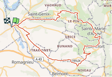

Length
25 km

Max alt
520 m

Uphill gradient
569 m
Km-Effort
32 km

Min alt
217 m

Downhill gradient
569 m
Boucle
Yes
Creation date :
2019-01-15 14:29:58.662
Updated on :
2019-01-15 14:29:58.662
1h49
Difficulty : Medium

FREE GPS app for hiking
 SityTrail
IGN / Geographical institutes
SityTrail Plus
The world is yours!
About
Trail Cycle of 25 km to be discovered at Auvergne-Rhône-Alpes, Isère, Aoste. This trail is proposed by leeho.
Description
Entraînement du premier jour
Positioning
Country:
France
Region :
Auvergne-Rhône-Alpes
Department/Province :
Isère
Municipality :
Aoste
Location:
Unknown
Start:(Dec)
Start:(UTM)
705021 ; 5052619 (31T) N.
Comments