


Ceyroux Montaigut

csy95
User
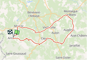

Length
39 km

Max alt
500 m

Uphill gradient
631 m
Km-Effort
48 km

Min alt
362 m

Downhill gradient
627 m
Boucle
Yes
Creation date :
2018-08-26 10:57:42.421
Updated on :
2018-08-26 10:57:42.421
2h40
Difficulty : Medium

FREE GPS app for hiking
 SityTrail
IGN / Geographical institutes
SityTrail Plus
The world is yours!
About
Trail Cycle of 39 km to be discovered at New Aquitaine, Creuse, Arrènes. This trail is proposed by csy95.
Positioning
Country:
France
Region :
New Aquitaine
Department/Province :
Creuse
Municipality :
Arrènes
Location:
Unknown
Start:(Dec)
Start:(UTM)
389536 ; 5103100 (31T) N.
Comments