


adeps mirwart 2018

gue
User
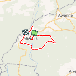

Length
9.4 km

Max alt
435 m

Uphill gradient
221 m
Km-Effort
12.4 km

Min alt
258 m

Downhill gradient
231 m
Boucle
Yes
Creation date :
2019-01-15 14:33:08.195
Updated on :
2019-01-15 14:33:08.195
1h31
Difficulty : Difficult

FREE GPS app for hiking
 SityTrail
IGN / Geographical institutes
SityTrail Plus
The world is yours!
About
Trail Walking of 9.4 km to be discovered at Wallonia, Luxembourg, Saint-Hubert. This trail is proposed by gue.
Positioning
Country:
Belgium
Region :
Wallonia
Department/Province :
Luxembourg
Municipality :
Saint-Hubert
Location:
Mirwart
Start:(Dec)
Start:(UTM)
662165 ; 5547325 (31U) N.
Comments