


Route de la Nacre

csy95
User
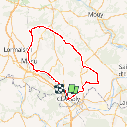

Length
51 km

Max alt
218 m

Uphill gradient
450 m
Km-Effort
57 km

Min alt
35 m

Downhill gradient
449 m
Boucle
Yes
Creation date :
2018-08-26 10:57:40.342
Updated on :
2018-08-26 10:57:40.342
3h19
Difficulty : Easy

FREE GPS app for hiking
 SityTrail
IGN / Geographical institutes
SityTrail Plus
The world is yours!
About
Trail Cycle of 51 km to be discovered at Hauts-de-France, Oise, Chambly. This trail is proposed by csy95.
Positioning
Country:
France
Region :
Hauts-de-France
Department/Province :
Oise
Municipality :
Chambly
Location:
Unknown
Start:(Dec)
Start:(UTM)
444588 ; 5445910 (31U) N.
Comments