


12.08.2018 - Mittlach

delm
User
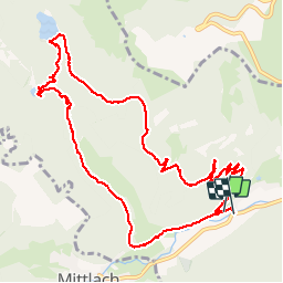

Length
11.7 km

Max alt
946 m

Uphill gradient
493 m
Km-Effort
18.4 km

Min alt
494 m

Downhill gradient
509 m
Boucle
Yes
Creation date :
2019-01-15 14:35:43.328
Updated on :
2019-01-15 14:35:43.328
3h29
Difficulty : Medium

FREE GPS app for hiking
 SityTrail
IGN / Geographical institutes
SityTrail Plus
The world is yours!
About
Trail Walking of 11.7 km to be discovered at Grand Est, Haut-Rhin, Metzeral. This trail is proposed by delm.
Description
Belle randonnée avec le 2 lacs par le sentier Monique
Positioning
Country:
France
Region :
Grand Est
Department/Province :
Haut-Rhin
Municipality :
Metzeral
Location:
Unknown
Start:(Dec)
Start:(UTM)
354740 ; 5319342 (32U) N.
Comments