


Moissac Toulouse

norihtom
User
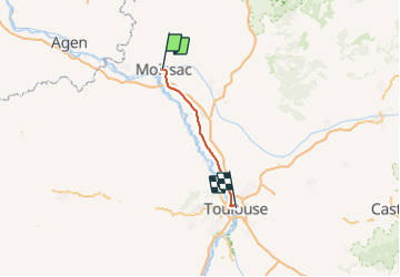

Length
70 km

Max alt
159 m

Uphill gradient
427 m
Km-Effort
76 km

Min alt
65 m

Downhill gradient
351 m
Boucle
No
Creation date :
2019-01-15 14:36:41.467
Updated on :
2019-01-15 14:36:41.467
4h30
Difficulty : Unknown

FREE GPS app for hiking
 SityTrail
IGN / Geographical institutes
SityTrail Plus
The world is yours!
About
Trail Cycle of 70 km to be discovered at Occitania, Tarn-et-Garonne, Moissac. This trail is proposed by norihtom.

Positioning
Country:
France
Region :
Occitania
Department/Province :
Tarn-et-Garonne
Municipality :
Moissac
Location:
Unknown
Start:(Dec)
Start:(UTM)
346319 ; 4885092 (31T) N.
Comments