


Toulouse Castelnaudary

norihtom
User
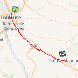

Length
63 km

Max alt
199 m

Uphill gradient
457 m
Km-Effort
69 km

Min alt
145 m

Downhill gradient
414 m
Boucle
No
Creation date :
2019-01-15 14:36:44.775
Updated on :
2019-01-15 14:36:44.775
4h05
Difficulty : Unknown

FREE GPS app for hiking
 SityTrail
IGN / Geographical institutes
SityTrail Plus
The world is yours!
About
Trail Cycle of 63 km to be discovered at Occitania, Haute-Garonne, Toulouse. This trail is proposed by norihtom.

Positioning
Country:
France
Region :
Occitania
Department/Province :
Haute-Garonne
Municipality :
Toulouse
Location:
Unknown
Start:(Dec)
Start:(UTM)
374859 ; 4829698 (31T) N.
Comments